 简体中文
简体中文 English
 繁体中文
繁体中文

East Tianshan + Kanas 12 days tour
{{item.d}}
¥{{form[item.str].price || 0}}
剩余:{{form[item.str].total || 0}}
Booking process

Overview of itinerary
Product Manager recommendation
We will walk into northern Xinjiang with you to appreciate the wonders left by nature.This journey will see pure natural landscapes,mountains,grasslands,lakes,and is a visual feast to enjoy the natural scenery!
Highlights
● At the foot of the Tian Shan Mountains,feel the magical power of the convergence of the mountain ranges.
● Travel to the Cocotosea Scenic Area and discover the secrets of the Irtysh River.
● Stand next to the rippling Kanas Lake and look for signs of the Kanas Monster.
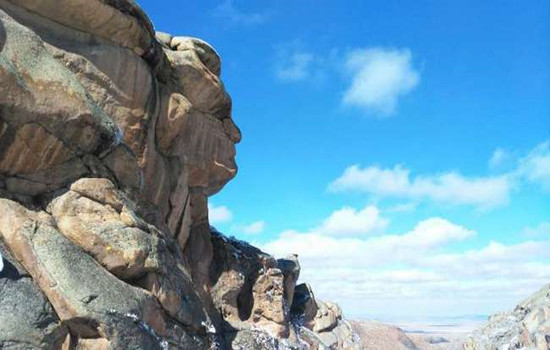
Enter the Devil City of Ulho and discover the mysteries left behind by nature
Travel overview
Detailed itinerary
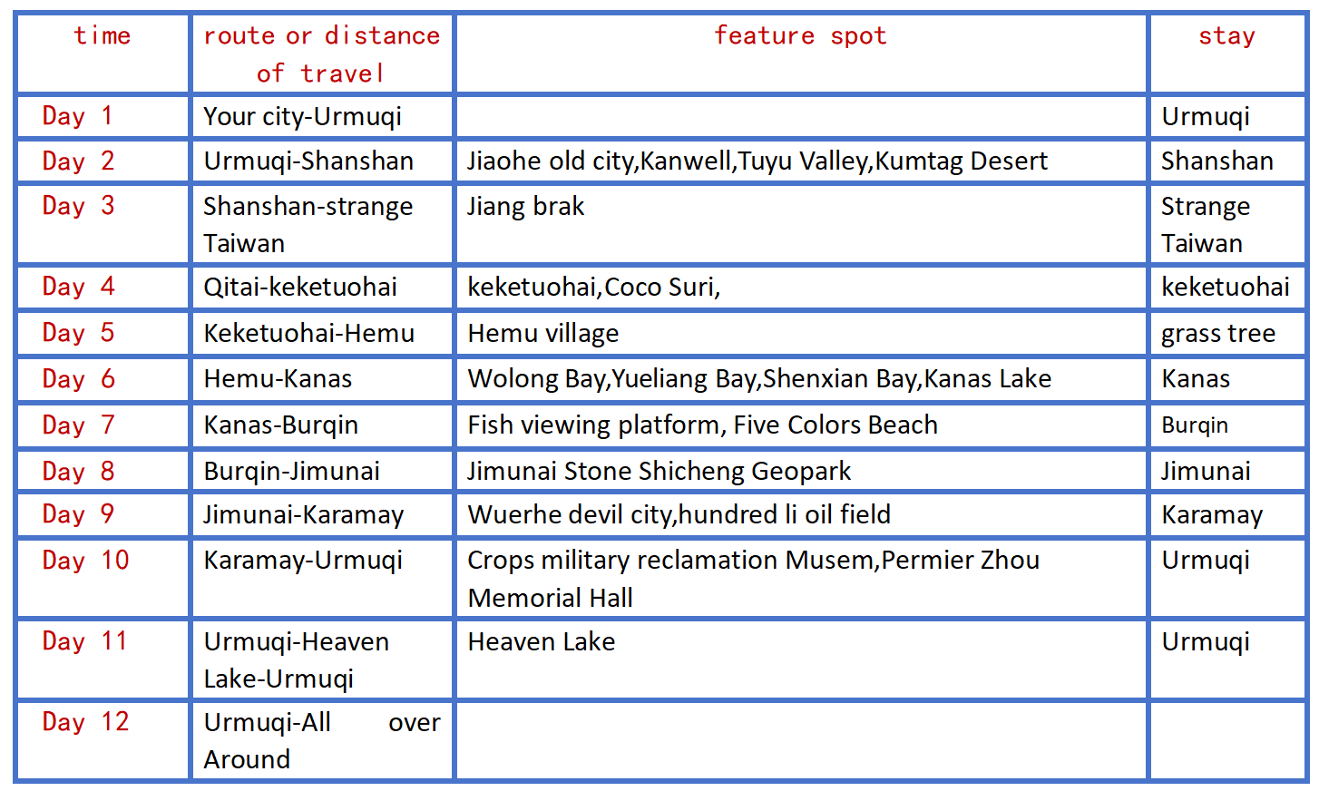
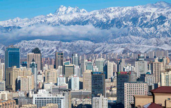
Day 1 Your city-Urumqi
Scheduling
Welcome to Damei Xinjiang! A professional pickup team will arrange the pickup / train to take you to the hotel for rest.If the time allows you to visit the recommended scenic spots by yourself (excluding a separate car).The departure time of the next day will be informed by the driver and the housekeeper with a message or telephone call before 22:00 PM.Please pay attention to check.
Recommended attractions
International bus za
It is a 4A scenic spot integrating characteristic buildings,ethnic commerce,singing and dancing,special food,jewelry and jade and other rich business forms.As a national cultural industry demonstration base and a platform for Xinjiang cultural and creative industry,it has a human flow of more than ten million people every year.It is an important cultural tourism landmark in Urumqi.It has now become a golden name card of Xinjiang cultural tourism,but also a "window to Xinjiang","Window to Central Asia" and "Window to the world".
Hongshan Park
The main red mountain is composed of purple conglomerate,the mountain is ochre red,very unique.In the park,you can walk in the forest,boating on the lake,you can visit the Buddhist temple statues and other cultural buildings,you can experience a variety of amusement projects,when you climb the top of the mountain,you can also overlook the panorama of the city,the content is rich,is a good place to relax in the area,but also a scenic spot for foreign tourists to visit the city.
The park area is not large,the length and width of about 500 meters,after entering can walk.There is a red mountain in the park,about 900 meters above sea level,but the drop with the mountain is only about one hundred or ten meters.There are many trees between the mountain road,and the environment is very good.Climbing here is not tired,and it takes about half an hour.If you lack physical strength,you can also take a sightseeing bus from the mountain to the top of the mountain.
The Xinjiang Uygur Autonomous Region Museum
(No ticket,need to be booked 1-3 days in advance,and the museum is closed every Monday.) It is the first batch of national first-class museums and provincial comprehensive geological museums.It is a cultural relic and specimen collection and protection,scientific research and publicity and education institution in Xinjiang Uygur Autonomous Region.
Recommended entertainment:International Bazaar Buffet Dinner,Silk Road Show,Kunlun engagement,etc
Food recommendation:
Xinjiang cuisine (no Page) chain restaurant: Xiao Gazi,fat old man,Loulan secret roast,Silk Road Date,Hetian rose scratch rice,pomegranate red,Musha barbecue
Special restaurant: lovely Xinjiang (with performance),Toxon 4 noodles,my son lamb,mountain fruit Lane tavern,blood station large plate chicken
Han restaurant: Medical school Li's restaurant,a 30 years old Han restaurant,the store does not accept WeChat,only cash,pig's feet and strange taste cool noodles are the first choice.
In recent years,Urmuqi has opened a lot of delicious Chinese restaurants,such as Xiaomei pigeon Hong Kong restaurant,all kinds of Chaoshan beef hot pot,small Dongting,Hunan Sichuan cuisine and so on.
kindly reminder:
1,Xinjiang is very large,scenic spots between a long drive,tourism is very physical energy,please bring some food or snacks,in case of emergency;
2.There is a two-hour time difference between Xinjiang and inland,breakfast in Xinjiang is around 8-9,lunch around 14 and dinner around 20.For better travel,I hope you can adjust your biological clock to the time difference in Xinjiang as soon as possible;

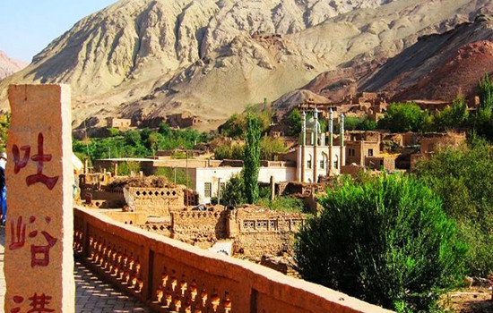
Day 2 Urumqi-Shanshan (about 300KM by car)
Today's scenic spots:
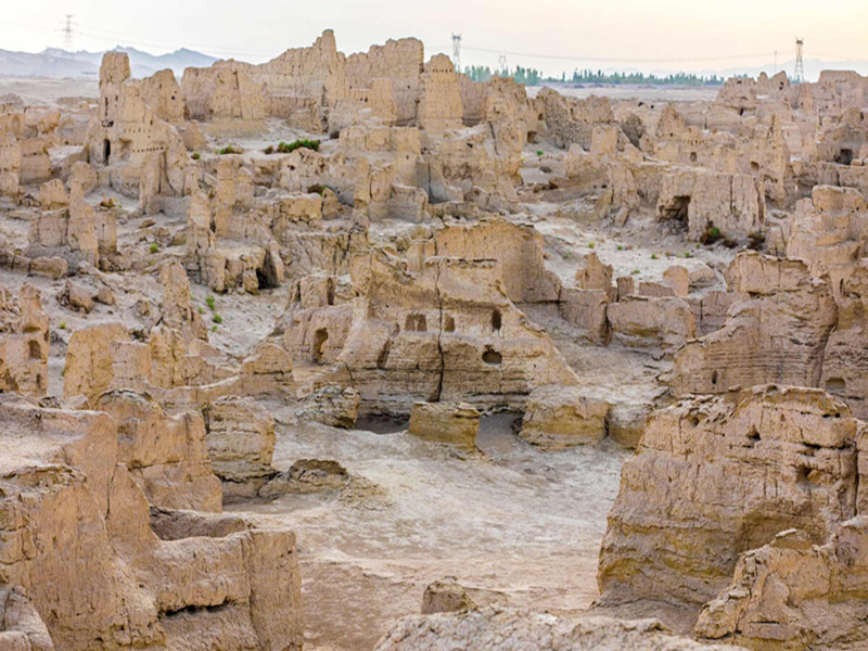
Jiaohe Ruins
Jiaohe city site,located in turpan city about 13 kilometers west of Yar township,the western suburb of Turpan city 10 kilometers eraizi ditch two rivers intersection 30 meters high loess platform,about 1650 meters long,both ends narrow,the widest about 300 meters,is a willow leaf shaped peninsula.It is the capital of the former state of the state of the ancient Western Regions,and is the political,economic,military and cultural center of the country.The drought and little rain in Turpan made the old city very complete.The buildings are all made of rammed earth plates,and the shape and layout are similar to that of Chang'an City in the Tang Dynasty.In the city,streets,offices,temples,stupas,streets,workshops,dwellings,performance fields,Tibetan trenches,temples and temples can also be found.The temple covers an area of 5,000 square meters,with a large water well.The pagoda group has 101 stupas.Looking down from the air,the Jiaohe old city looks like a big willow leaf.
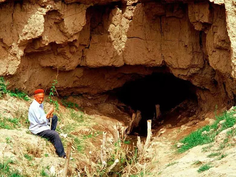
kariz
Karez is a kind of underground water conservancy project created in the long historical development of the working people in the arid land.The karez drew out the groundwater,turning the desert into an oasis,called the "well canal" in ancient times.The main working principle of karez is that people use a large amount of rainwater,glaciers and snow melt water seeping into the ground in spring and summer by using the natural slope of the mountain to draw out the surface for irrigation,so as to meet the demand of production and living water in desert areas.Karez in different regions have different regional characteristics in specific structure,but generally speaking,a complete karez system includes four main components: shaft,culvert (underground channel),open channel (ground channel) and fault occurrence (small reservoir).Under this principle,the flow of the arez is stable and the irrigation of well water can be guaranteed.
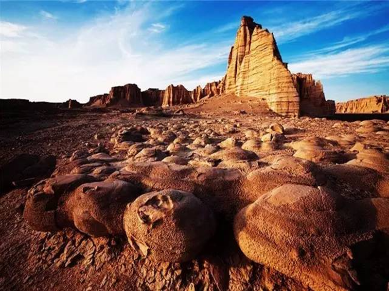
Kumutag Desert
Kumtag Desert,covering an area of 2,500 square kilometers,is located at the southern end of Shanshan Old Town,Xinjiang Province,which is one of the few deserts in the world that has close contact with cities.It is characterized by complete sand landforms,clear outline and distinct layers of sand dunes.Kumtag means "sand mountain" in Uyghur language,and Kumtag Desert is "desert with sand mountain".
Library wood tower desert mainly because from tianshan seventeen well tuyere southwest wind and daban city tuyere southeast wind,along the changfeng journey,with a lot of sand,finally meet in library wood tower area collision and deposition,south of cook tag mountain also contributed to two directions of wind weakening and sand deposition,forming "sand mountain desert" the unique landscape.Therefore,the Kumtag Desert has become a scenic spot integrating scientific research,investigation,exploration,sand sports,sand therapy and health care,and desert sightseeing.The temperature difference between day and night in the sand mountain is large.In midsummer,the surface sand temperature is 70℃,and the highest is 82.3℃.The eggs can be buried in the sand.
Tuyugou Maza Village
Mazha Village belongs to the climate zone south of the Flaming Mountain.It is a historical and cultural ancient village integrating human landscape and natural landscape,Buddhist culture and Western culture.With a history of more than 2,600 years,Mazha Village is a typical representative of the village pattern under the Islamic cultural background in eastern Xinjiang,showing the traditional Uygur style of "ancient villages,ancient houses,ancient alleys and ancient trees".There is Tuyugou Grottoes,a national key cultural relic protection unit,in the north of Mazha Village,and Huojiamu Mazha in the west.A large number of traditional houses built with raw soil are preserved in the village,which is a model of raw soil architecture in Xinjiang and is known as "the first soil village in China".
Scheduling
The world's largest and oldest and best preserved native building city,is also the most complete urban relics preserved in China for more than two thousand years.Anxi Frontier Command,the highest military and political organization in the Western Regions of the Tang Dynasty,was first located in the old city of Jiaohe.Walking in the city,there is a feeling through thousands of years,dream back to the Tang Dynasty.
With a history of more than 2,000 years,Karez,as the source of life of turpan people,is an indispensable scenic spot in this trip!
The Maza Village in Tuyugou is surrounded by mountains and built by oasis.The Subexi River runs through the village,connecting six clusters.Village cultivated land is near the water distribution,residential houses and cultivated land depend on each other,living near the water.The residential houses are built on the platform between the slope,which are 30 to 50 groups with the terrain,scattered and integrated into the environment,and the reasonable result of the slope valley terrain and the desert Gobi terrain and climate facing the sun.
The Kumtag Desert scenic area in Shanshan County.On the golden sand mountain,you can see the long yellow sand and rolling sand ridge,connected with the sky,giving people a vast,magnificent,solemn and profound feeling.Standing at the junction of the oasis and the desert,watching the square scenery,the strange scenery in front of the amazing: one side is the vast,vigorous,boundless desert ocean; the other side is the lush,beautiful and charming oasis green wild.This is the outstanding nature of nature,there is no transition between yellow and green,but the two colors form a sharp contrast,just like the painter's color plate,yellow and green,strong contrast and harmonious unity,it is amazing.
kindly reminder:
1,Turpan perennial drought and less rain,pay attention to small drink water,heat and sun protection
2,Jiaohe old city is a cultural relic site,do not take photos on the plank road or climb to the earth wall to take photos,pay attention to the protection of cultural relics!
3,enter the desert scenic area to pay attention to your belongings,small items must be collected in advance,similar to bracelets,necklaces,rings and other valuable jewelry fell into the sand,it is difficult to find back.
4.If you want to take Tekestured photos in the desert,you can wear white,black,red,and you can take several more sets of clothes for a change.Men can wear black coats and take cool pictures.
5.If you want to make some videos like the ethereal air,then the red skirts and scarves must be ready.Silk scarf is the best god in the desert collocation.The silk scarf at the gate of the scenic spot is 35 yuan each.Choose the white or red silk scarf.

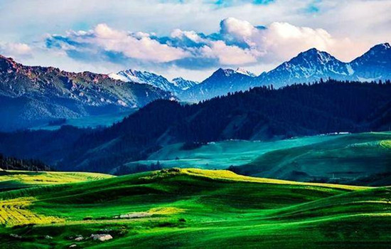
Day 3 Shanshan-Qitai (about 300KM by car)
Today's attractions: Jiangbulak
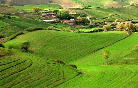
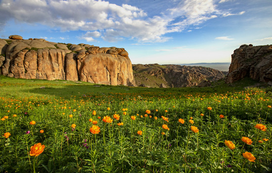
Jiangbulak is a Kazakh language,meaning the source of holy water.She gathered the aura of the Tianshan Mountains,and incorporated many beautiful legends.Here,the distant mountains near the water set each other off,the forest and snow peaks blend,green waves and flowers like tide,a holy natural scenery.The beautiful Jiangbulak attracts the attention of many visitors with its beautiful and charming scenery,including the beautiful and quiet black waterlogging dam,the most Tianshan slope in the world,and the idyllic scenery across the fields.
It is a perfect combination of vertical integrated mountain landscape in typical temperate arid areas and unique mountain wheat field prints.It is the continuous landscape of tianshan World Natural Heritage site in Xinjiang,and has been identified by the Chinese Academy of Sciences as one of the earliest oasis cultures of the most complete protection.Scenic spot resources huge entity,rich species,formed by farming culture,the culture,nomadic culture and so on nine big culture for background,to sightseeing photography,leisure,scientific research,popular science education,hiking adventure,kang fitness as the main function of characterization,quality,compound international leisure holiday scenic area,is the Xinjiang "tianshan li golden line" one of the core,known as a natural oxygen bar,green kingdom,photography,hiking paradise,is a fairyland under the tianshan arms.
Scheduling
Driving across the Tianshan Mountains in the Mushan road,there are many small wild animals along the way to attract people to stop.
In addition to the thousands of acres of wheat fields all over the hills seem to be in a European town,there is a magical strange slope of the Tianshan Mountain,riding on the downhill slope without effort.There is also the most famous symbol —— "knife pick ridge".Between the extended snow-capped mountains,there is a high snow-capped mountain,in a long strip,standing like a blade,so the local herdsmen call it "knife pick ridge".
kindly reminder:
1、Jiangbulak scenic spot is at the top of the mountain.Before entering the scenic spot,watch the weather changes and be ready to add coats around you
2、If you want to ride a horse in the scenic area,please say the price and time in advance before riding the horse.Please do not walk behind the horse so as not to cause safety problems.
Day 4 Qitai-keketuohai (about 300KM)
Today's attractions: Coco suri
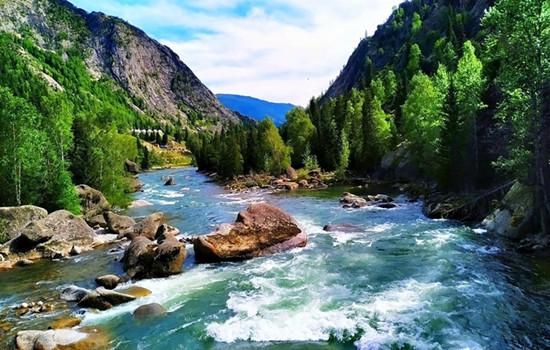
It is one of the main scenic spots of Keketuohai National Geopark,23 kilometers away from Fuyun County,Hoh Xil Lake,also known as Wild Duck Lake,with an area of 2677 mu,an average water depth of 2 meters,and more than 20 floating islands formed by staggered reeds in the lake,rich in aquatic plants.
Keketuohai National Geopark
keketuohai Scenic Spot (namely Ertyses Grand Canyon Scenic Spot) is the source of the Ertyses River,a famous river in northern Xinjiang.The scenic spot is about 20 kilometers long,among which there are more than a dozen scenic spots such as birch forest,Shuiditch,Shenzhong Mountain,and hot spring,all along the Ertyses River.There are interval cars in the scenic area,which is a round-trip ticket from the scenic area gate to Shenzhong Mountain (17 kilometers one way).Intercars operate in a way similar to a bus,with a few stops in the middle,tourists get off to visit the surrounding scenic spots and then wait for the next car.There is still 6.5 kilometers away from the hot spring in the deep canyon.You need to go on foot.If you do not have enough physical strength,you can also take the patrol car in the scenic area.
In the gate of the scenic area to Shenzhong Mountain a section of the more key scenic spots are birch forest,water mill ditch,Hongye ditch and Shenzhong Mountain.There are also a lot of strange peaks and rocks along the road,in the middle of the Ertysh River is clear and magnificent,you can have a good play.
Scheduling
Starting from the hotel,along the G216 national Road to Fuyun County,the Gobi scenery is also an indispensable beauty along the way.
Arrive in Cocosuri Scenic area,punch in and take photos,and go to keketuohai Town.
Arrive at Cocato Sea Scenic spot.It takes about 10-15 minutes from the parking lot all the way to the ticket office,and the interval car takes about an hour.Get off at the end of the interval car and return to the original way.There is a battery car beside the bridge below Shenzhong Mountain,and you can walk another 3 kilometers into the canyon.This fee is not included in the interval ticket of the scenic area,so you need to buy a ticket here alone.Do not take the battery car can play in the river,or next to a mountain mountain play.Pay attention to safety along the way.After the original road back to the parking lot to take the interval car to the entrance of the scenic spot.
kindly reminder:
1.Large temperature difference between morning and evening,Take long-sleeved clothes with you.Suitable for light hiking,to wear comfortable shoes;
2.216 national Road speed limit,driving time is long,please bring snacks and fruit;
Day 5 keketuohai-Hemu (4 about 60 KM)
Today's attractions: Hemu
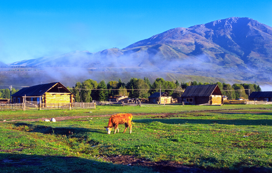
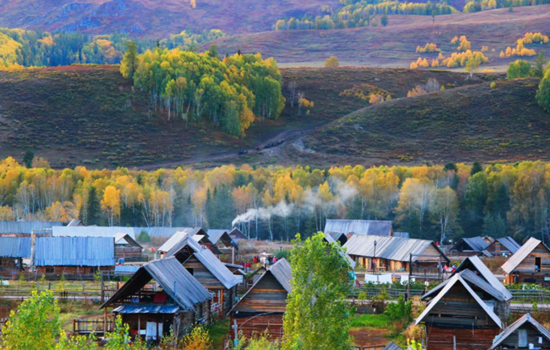
Hemu River flows from northeast to southwest,natural and primitive mountain scenery,primitive village and the prairie harmonious and natural integration.When we come to Hemu Village,the first thing to enter our view is the small cabins and groups of herds,together with snow peaks,forests,grassland,and constitute a unique natural and cultural landscape with blue sky and white clouds.
Its significance is that these cabins have become the symbol of the Tuva people.Most of the cabins are buried in the soil to resist the cold of the snow for nearly half a year,which is particularly primitive and simple,and has the traditional characteristics of nomadic people.The roof is generally nailed with wood adult type canopy,the room body with a diameter of 30 centimeters of 30 or a single layer of log pile,both warm and moisture-proof.
On the hillside around Hemu Village,you can overlook the panoramic view of Hemu Village and Hemu River,view the sunrise,snow peaks and trickle streams,and visit the Tuwa family.It is the best place to shoot the sunrise,morning fog,wooden house and Hemu River.
Scheduling
From the hotel,all the way north to Hemu Village,timely lunch along the way.Along the way,flocks of cattle and sheep,blue sky and white clouds of the grassland,are all people always want to stop involved.
After arriving at the gate of Hemu Scenic area,change the interval car to enter.Although you can not stop to take photos,the scenery outside the window will let people experience the beautiful scenery is always three points in the scenic spots,seven points on the road.
First find the home stay,put down your luggage,you can go to the viewing platform to overlook the whole village.The fastest return time is about 2 hours.You can also enjoy free activities in the river and birch forest to enjoy the lazy leisure time of the wood.
kindly reminder:
1、 On the day of the whole mountain road,carsickness tourists must pay attention to prepare medicine in advance
2、 The scenery along the way to the scenic area is infinitely good.If you need to get off to take photos and punch in,please communicate with the master in advance,and find a safe area to stop before getting off.When you need to cross the road,please pay attention to the passing vehicles and pay attention to the safety on the road.
3、 Due to the remote location of Hemu Village,the prices in the scenic area will be relatively high than those in the city.Please prepare the required items in advance.
4、Hemu Village is mainly wooden homestay or wooden villa,can choose to stay limited,need to have psychological preparation in advance.
Day 6 Hemu-Kanas (about 100KM)
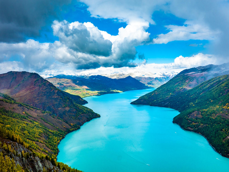
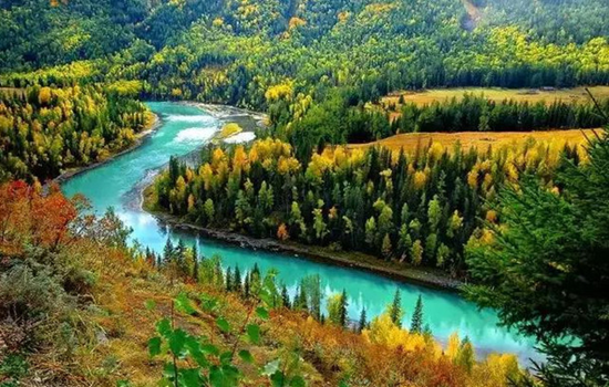
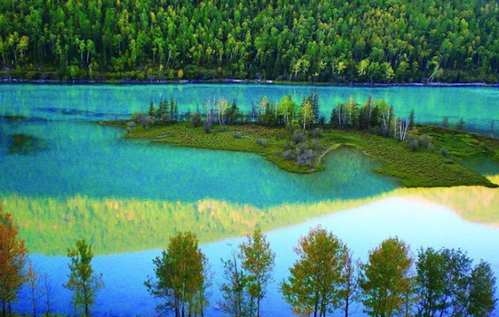
Today's attractions: Kanas
With the majestic scenery of the north,and the beauty of the Jiangnan landscape,in addition,there are "sea of clouds Buddha light","color lake","float wood long dike","lake monster" and other beautiful scenery,how can not be called the western regions of the beautiful scenery,fairy scenery.To the north is the snow-covered Kuitun Mountain,the towering Friendship Peak.Around the lake,the mountains,the mountains like a painted screen.Different plant communities have distinct layers and different colors.
Scheduling
By interval car into the kanas scenic area,through kanas famous three bay "Shenxian Bay,Yueliang Bay,wolong bay" to the Shenxian Bay water become sparkling,like flashing pearl necklace,then arrived at the Yueliang Bay,overlooking the like a huge footprints in crescent river,and then to wolong bay,like the sword in the Jurassic park,lying in the middle of the river
You can walk in the ancient Kanas Tuwa village,also can go to the Kanas Lake by car,in the peaceful and mysterious,beautiful fairy tale world,temporarily put down the anxiety of city life,meditation eyes,open arms to embrace the quiet and empty here.
kindly reminder:
1,there are many mountain roads,please carsickness tourists must pay attention to prepare carsickness medicine in advance;
2,To enter the Kanas scenic area,you must transfer to the regional car in the scenic area,because the interval car is a cycle,there are many stops along the way,in order to facilitate sightseeing,it is strongly recommended to carry the items needed that night,light to enter the scenic area,large luggage temporarily on their own tourist car;
3, In order to facilitate you to have more tour time in the scenic area,so regardless of the cost of special accommodation in the scenic spot,but due to the poor local infrastructure and environmental requirements,the accommodation conditions in the scenic area are poor,please make psychological preparation in advance;
4,There are still many local residents living in the scenic area,please do not tease cats and dogs,stay away from animals.When communicating with the local residents,please respect the local customs and habits.
5,According to the regulations of the scenic spot,hiking is not allowed,and smoking is not allowed.Please cooperate。
Day 7 Kanas-Burqin (about 180KM)
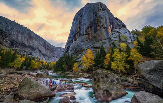
Today's scenic spot: a fish viewing platform
The fish Pavilion is located on the top of a mountain near the lake,700 meters relative to the lake.It takes about one and a half hours to climb the artificial stone ladder from the lake.After the view of the fish pavilion,there is a dirt road to reach the top of the mountain,but there is no feeling.Part of the fish pavilion hangs in the middle of the summit,but this half is the most critical position to look at Kanas Lake.
Scheduling
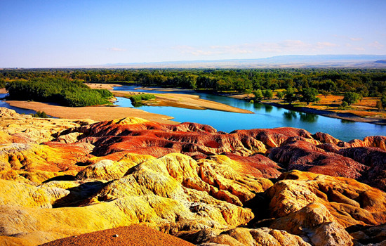
Go to the transfer center to take the interval bus on the fish platform.On the view of the fish platform,go up the mountain to see the lake,down the mountain to see the scenery,enjoy the highlight of the Kanas central scenic spot!Return from the transfer center to the gate of JiadValley Scenic area,and return to Burqin for the tour bus.After returning to Burqin County go to Wucaitan Scenic area,which is located in the arid and windy area,due to the riverbank rocks。
The strength of weathering resistance is different,forming an uneven outline.The rock layer is composed of red,earth red,light yellow and light green sandstone,mudstone and conglomerate.The rock has different colors,colorful,such as colorful castles,monsters,peaks and other strange landforms,which is a typical colorful hills.When the wind rises,it will make a strange sound,adding a mysterious color.
kindly reminder:
1.Please take your belongings to avoid losing them.
2.The sunset time of the Five Colors Beach varies with the season.If there is no sunset,the weather may not be able to watch the sunset,please prepare psychologically in advance.

Day 8 Burqin-Jimunai (about 200KM)
Today's scenic spot: Jimunai Stone Shicheng Geopark
The granite landform in the park is rich and typical,it is a dry area in China,with a large scale and a "god" shape.It is a granite rock egg landform landscape area dominated by wind erosion.It has a variety of micro-landforms,such as granite egg landform,stone egg piling landform,stone mound,stone cave,stone cave,stone basin,stone forest,stone column,stone trough,cliff and so on,and can be called the museum of granite wind erosion landform.
Scheduling
To Jimu is Shenshi City Geopark,the park not only has mysterious grassland stone figures,there are many different forms of granite landforms,is currently rare in the northern Xinjiang minority scenic spots.
kindly reminder:
1. Today schedule arrangemant is free.
Day 9 Jimunai-Karamay (about 400KM)
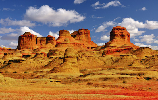
Today's attractions: Ulhe Devil's City
Ulhe Devil City,also known as Uerhe Wind City,100 kilometers away from Karamay City,is a unique wind erosion landform,strange shape scenery makes the local Mongols call this "SulumHak".The Uighurs called it "Shayi tank si",which means where the devil lives.In fact,here is a typical Yadan landform area,in the northwest,east and west,the length and width of about more than 5 kilometers,a radius of about 10 square kilometers,the ground is about 350 meters above sea level.
According to investigation,about one hundred million years ago in the Cretaceous,here is a huge freshwater lake,shore with lush plants,water habitat breeding ur wo,plesiosaurs,dinosaurs,junggar pterosaurus and other ancient animals,here is a aquarium gathered "heaven",then after two big crust changes,the lake became sandwiched between sandstone and mudstone land vast,geology called it "gobi platform".
Scheduling
Along the G217 national Road to Karamay,through the observation platform of BaijiBeach area,you can see the dense oil production machine standing in the vast Gobi Desert,as if entering the movie scene of science and technology blockbuster.
kindly reminder:
1.Strong windy,hot in summer,has avoided the midday sun,but the climate is dry,pay attention to sunscreen and water; please prepare for sunscreen and heatstroke in advance.
2.The observation platform of Baili oilfield is the oil production area of the oilfield,and fireworks are strictly prohibited.

Day 10 Karamay-Urmuqi (about 400KM)
Today's scenic spot:
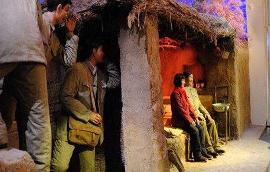
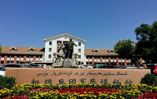
Corps military reclamation Museum
Located in Shihezi City,it is a special museum reflecting the history and development of military reclamation of Xinjiang Production and Construction Corps.Through numerous cultural relics,picture descriptions show the ancient history of Shihezi,the history of military reclamation and subsequent development,etc.,is a good place to understand the history of the production and construction corps.
Premier Zhou Memorial Hall
In the northern suburb of Shihezi City,3 kilometers from the city center.The south side of the monument is the Prime Minister's Memorial Hall,and the north side is the memorial Hall.The inscription on the south side is the inscription of Premier Zhou's inspection of the Corps in 1965,the inscription on the north side is an excerpt of the government work report made by Premier Zhou at the Third National People's Congress,and the inscription on the back is the inscription of the construction.Overall view of the monument,tall and tall,dignified shape,simple and vigorous style,the flowers and pines in front of the monument,giving people a mild and serious sense.
Scheduling
Arrived in Xinjiang's garden city - Shihezi City,visit the Corps military reclamation museum,through a large number of cultural relics,picture captives show the ancient history of Shihezi,military reclamation monument,is also a local red patriotism education base.
kindly reminder
If the museum is closed on Monday,this view will be cancelled.
Day 11 Urmuqi-Heaven Lake-Urmuqi (about 200KM)
Today's attractions:
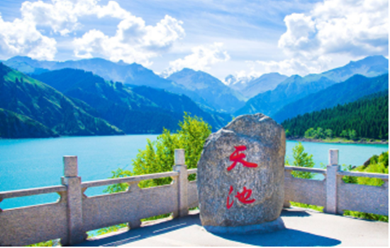
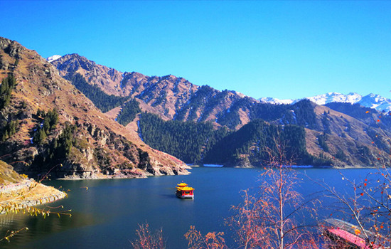
Heaven Lake
There are three water surfaces in the Tianchi,in addition to the main lake,there are two water surfaces on the east and west sides,the east side is the East Little Tianchi,the ancient name of Heilongtan,located 500 meters east of the Tianchi,legend is the face of the Queen Mother.Under the pool for the cliff,there is a waterfall flowing down,just like a rainbow according to the sky,is spectacular,to help a scene day "hanging spring Yao hong".The west side is the West Little Tianchi,also known as the Jade Woman Pool,according to legend that the Queen mother of the West wash feet,located two kilometers northwest of the Tianchi.West small Tianchi like a full moon,the water is clear and deep,surrounded by tower pine.If the bright moon is in the sky,the quiet shadow sinks to the wall,and the clear scene is infinite,so we also have a scene said: "Longtan blue moon".The side of the pool also flies hanging a waterfall,tens of meters high,such as the Milky Way landing,spit beads splashing jade,the scene is called "jade belt silver curtain".There is a pavilion on the pool,the pavilion view the waterfall is interesting.Eyes can see the curtain roll pool tao,pine cui water blue; ears can hear the water through the rock,sound shock rift.
Scheduling
From the hotel parking lot along the Tianshan Tianchi Scenic area.
After the ticket procedures,all tourists must change the interval car to enter.Every day after 10 a.m.,the bus will stop at the Folk Village.All tourists have to get through the bus from the village to the next boarding point to get on the bus.Along the way,there are selling barbecue,naan,ethnic handicrafts and other stalls.After arriving at the parking lot at the top of the mountain,hiking to the lake and 1.5KM,you can walk or sit
battery car.
kindly reminder:
1,the scenic spot has strong ultraviolet light during the day,please take sunscreen measures.The lake temperature is not high,but the ultraviolet light penetration is very strong;
2,on the top of the mountain,pay more attention to keep warm (2300 meters above sea level) there are few restaurants in the scenic area,and far away from the door of the scenic spot,so if you want to stay in the scenic area for a long time,to calculate the good time to eat,otherwise you should prepare some dry food to carry.
Day 12 Urumqi-Your city
Arrange the flight / station according to the flight / train information,end the deep journey of northern Xinjiang,return to the warm home! Welcome to visit Xinjiang again!
The trip time node is for reference only,subject to the actual participants