 简体中文
简体中文 English
 繁体中文
繁体中文

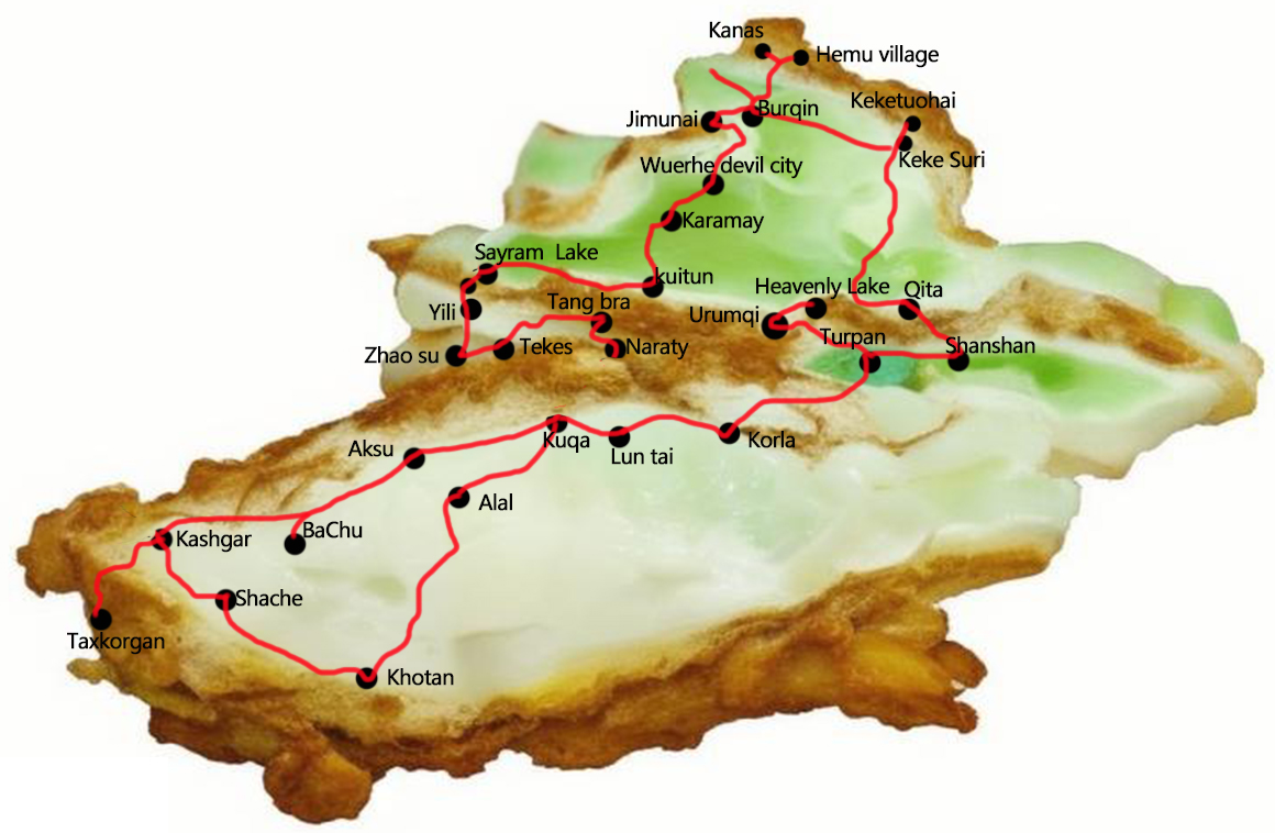
Southern and Northern Xinjiang big ring road 35 days tour
{{item.d}}
¥{{form[item.str].price || 0}}
剩余:{{form[item.str].total || 0}}
Overview of itinerary
Product Manager recommendation
During this journey, you can slow down the pace and deeply explore the entire Xinjiang. We have included all the attractions in southern and northern Xinjiang. Starting from Urumqi, we will spend 35 days traveling from the plains to the plateau, from the grasslands to the lakes, and from the cities to the villages, taking in the breathtaking natural scenery of Xinjiang and immersing yourself in its captivating landscapes.
Highlights
● Travel to the Keketuohai Scenic Area and discover the secrets of the Irtysh River.
● Stand next to the rippling Kanas Natural Reserve and look for signs of the Kanas Monster.
● Stand on the shore of the White Sand Lake and feel the fine white sand and soft breeze.
● Enter the Devil City of Ulho and discover the mysteries left behind by nature.
● Cross the Panlong Ancient Road, enter the Pamir Plateau, erase all troubles
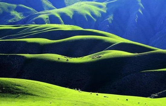
● Enter the world's most beautiful grassland - Naraty grassland, free yourself on the grassland
● Cross the Pamir Plateau in search of apricot flowers that grow in the valleys.
Travel overview
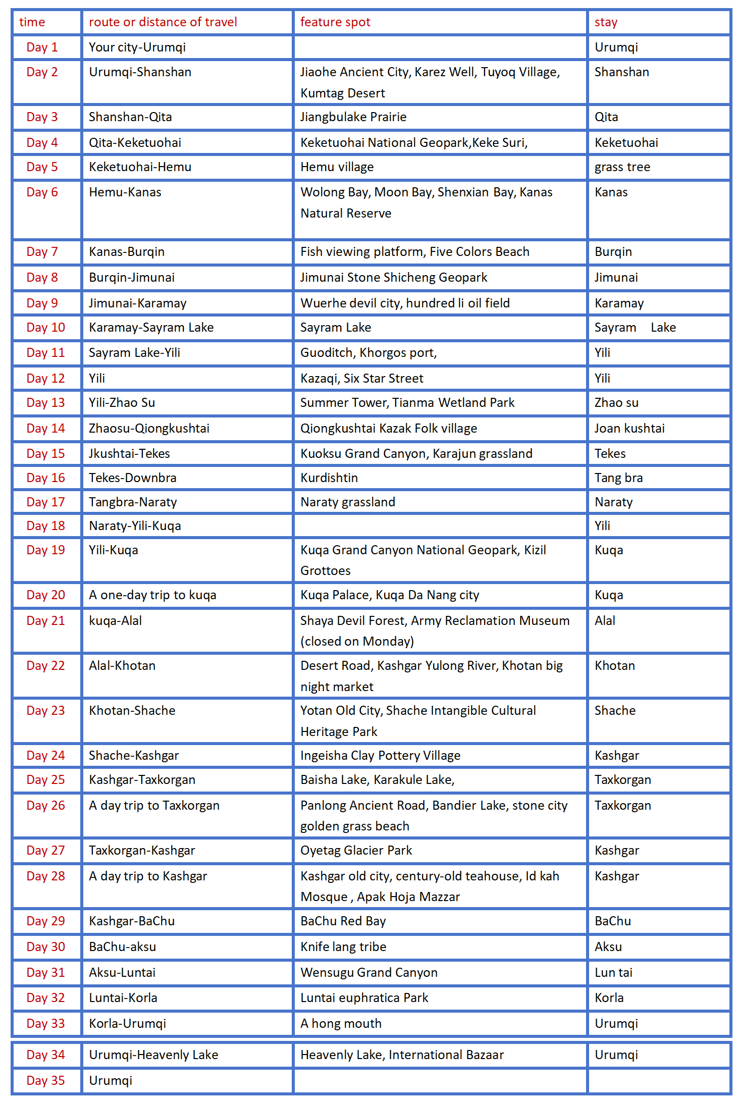
Detailed itinerary
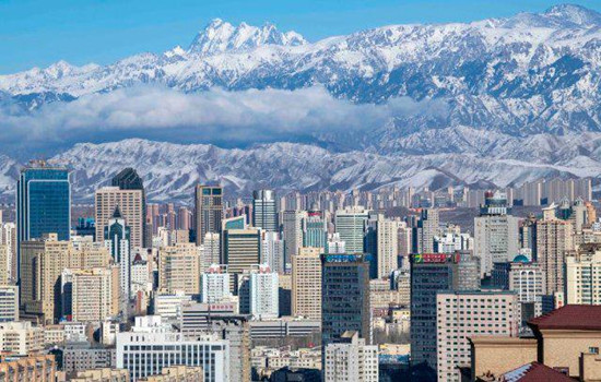
Day 1 Your city-Urumqi
Itinerary
Welcome to Damei Xinjiang! A professional pickup team will arrange the pickup / train to take you to the hotel for rest. If the time allows you to visit the recommended scenic spots by yourself (excluding a separate car). The departure time of the next day will be informed by the driver and the housekeeper with a message or telephone call before 22:00 PM. Please pay attention to check.
Recommended attractions
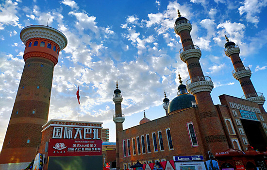
International Bazaar
It is a 4A scenic spot integrating characteristic buildings, ethnic commerce, singing and dancing, special food, jewelry and jade and other rich business forms. As a national cultural industry demonstration base and a platform for Xinjiang cultural and creative industry, it has a human flow of more than ten million people every year. It is an important cultural tourism landmark in Urumqi. It has now become a golden name card of Xinjiang cultural tourism, but also a "window to Xinjiang", "Window to Central Asia" and "Window to the world".
Hongshan Park
The main red mountain is composed of purple conglomerate, the mountain is ochre red, very unique. In the park, you can walk in the forest, boating on the lake, you can visit the Buddhist temple statues and other cultural buildings, you can experience a variety of amusement projects, when you climb the top of the mountain, you can also overlook the panorama of the city, the content is rich, is a good place to relax in the area, but also a scenic spot for foreign tourists to visit the city.
The park area is not large, the length and width of about 500 meters, after entering can walk. There is a red mountain in the park, about 900 meters above sea level, but the drop with the mountain is only about one hundred or ten meters. There are many trees between the mountain road, and the environment is very good. Climbing here is not tired, and it takes about half an hour. If you lack physical strength, you can also take a sightseeing bus from the mountain to the top of the mountain.
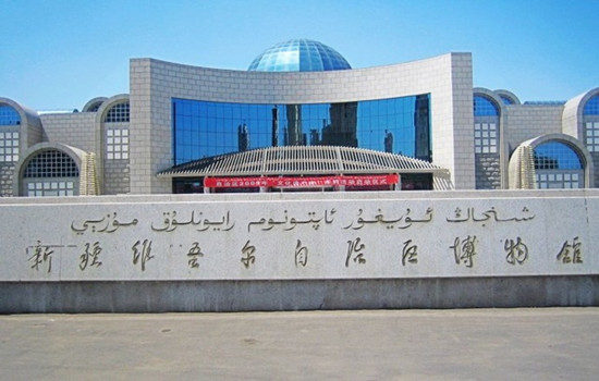
The Xinjiang Uygur Autonomous Region Museum
(No ticket, need to be booked 1-3 days in advance, and the museum is closed every Monday.) It is the first batch of national first-class museums and provincial comprehensive geological museums. It is a cultural relic and specimen collection and protection, scientific research and publicity and education institution in Xinjiang Uygur Autonomous Region.
Recommended entertainment:International Bazaar Buffet Dinner, Silk Road Show, Kunlun engagement, etc
Food recommendation:
Xinjiang cuisine (no Page) chain restaurant: Xiao Gazi, fat old man, Loulan secret roast, Silk Road Date, Khotan rose scratch rice, pomegranate red, Musha barbecue
Special restaurant: lovely Xinjiang (with performance), Toxon 4 noodles, my son lamb, mountain fruit Lane tavern, blood station large plate chicken
Han restaurant: Medical school Li's restaurant, a 30 years old Han restaurant, the store does not accept WeChat, only cash, pig's feet and strange taste cool noodles are the first choice.
In recent years, Urumqi has opened a lot of delicious Chinese restaurants, such as Xiaomei pigeon Hong Kong restaurant, all kinds of Chaoshan beef hot pot, small Dongting, Hunan Sichuan cuisine and so on.
kindly reminder:
1, Xinjiang is very large, scenic spots between a long drive, tourism is very physical energy, please bring some food or snacks, in case of emergency;
2. There is a two-hour time difference between Xinjiang and inland, breakfast in Xinjiang is around 8-9, lunch around 14 and dinner around 20. For better travel, I hope you can adjust your biological clock to the time difference in Xinjiang as soon as possible;
Day 2 Urumqi-Shanshan (about 300KM by car)
Today's scenic spots:
Jiaohe Ancient City
Jiaohe city site, located in turpan city about 13 kilometers west of Yar township, the western suburb of Turpan city 10 kilometers eraizi ditch two rivers intersection 30 meters high loess platform, about 1650 meters long, both ends narrow, the widest about 300 meters, is a willow leaf shaped peninsula. It is the capital of the former state of the state of the ancient Western Regions, and is the political, economic, military and cultural center of the country. The drought and little rain in Turpan made the old city very complete. The buildings are all made of rammed earth plates, and the shape and layout are similar to that of Chang'an City in the Tang Dynasty. In the city, streets, offices, temples, stupas, streets, workshops, dwellings, performance fields, Tibetan trenches, temples and temples can also be found. The temple covers an area of 5,000 square meters, with a large water well. The pagoda group has 101 stupas. Looking down from the air, the Jiaohe old city looks like a big willow leaf.
Karez Well
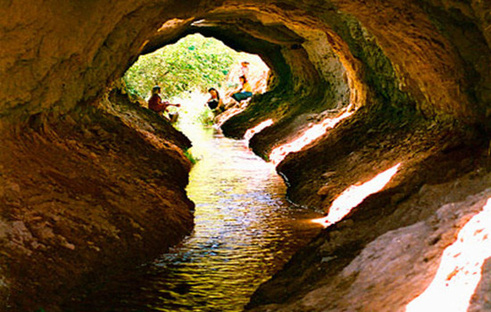
Karez Well is a kind of underground water conservancy project created in the long historical development of the working people in the arid land. The Karez Well drew out the groundwater, turning the desert into an oasis, called the "well canal" in ancient times. The main working principle of Karez Well is that people use a large amount of rainwater, glaciers and snow melt water seeping into the ground in spring and summer by using the natural slope of the mountain to draw out the surface for irrigation, so as to meet the demand of production and living water in desert areas. Karez Well in different regions have different regional characteristics in specific structure, but generally speaking, a complete Karez Well system includes four main components: shaft, culvert (underground channel), open channel (ground channel) and fault occurrence (small reservoir). Under this principle, the flow of the arez is stable and the irrigation of well water can be guaranteed.
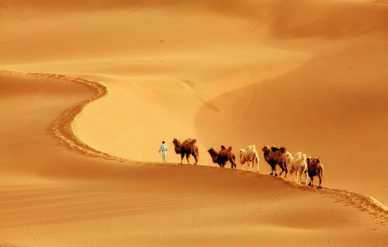
Kumutag Desert
Kumtag Desert, covering an area of 2,500 square kilometers, is located at the southern end of Shanshan Old Town, Xinjiang Province, which is one of the few deserts in the world that has close contact with cities. It is characterized by complete sand landforms, clear outline and distinct layers of sand dunes. Kumtag means "sand mountain" in Uyghur language, and Kumtag Desert is "desert with sand mountain".
Library wood tower desert mainly because from tianshan seventeen well tuyere southwest wind and daban city tuyere southeast wind, along the changfeng journey, with a lot of sand, finally meet in library wood tower area collision and deposition, south of cook tag mountain also contributed to two directions of wind weakening and sand deposition, forming "sand mountain desert" the unique landscape. Therefore, the Kumtag Desert has become a scenic spot integrating scientific research, investigation, exploration, sand sports, sand therapy and health care, and desert sightseeing. The temperature difference between day and night in the sand mountain is large. In midsummer, the surface sand temperature is 70℃, and the highest is 82.3℃. The eggs can be buried in the sand.
Itinerary
The world's largest and oldest and best preserved native building city, is also the most complete urban relics preserved in China for more than two thousand years. Anxi Frontier Command, the highest military and political organization in the Western Regions of the Tang Dynasty, was first located in the old city of Jiaohe. Walking in the city, there is a feeling through thousands of years, dream back to the Tang Dynasty.
With a history of more than 2,000 years, Karez Well, as the source of life of turpan people, is an indispensable scenic spot in this trip!
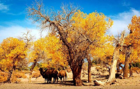
The Maza Village in Tuyugou is surrounded by mountains and built by oasis. The Subexi River runs through the village, connecting six clusters. Village cultivated land is near the water distribution, residential houses and cultivated land depend on each other, living near the water. The residential houses are built on the platform between the slope, which are 30 to 50 groups with the terrain, scattered and integrated into the environment, and the reasonable result of the slope valley terrain and the desert Gobi terrain and climate facing the sun.
The Kumtag Desert scenic area in Shanshan County. On the golden sand mountain, you can see the long yellow sand and rolling sand ridge, connected with the sky, giving people a vast, magnificent, solemn and profound feeling. Standing at the junction of the oasis and the desert, watching the square scenery, the strange scenery in front of the amazing: one side is the vast, vigorous, boundless desert ocean; the other side is the lush, beautiful and charming oasis green wild. This is the outstanding nature of nature, there is no transition between yellow and green, but the two colors form a sharp contrast, just like the painter's color plate, yellow and green, strong contrast and harmonious unity, it is amazing.
kindly reminder:
1, Turpan perennial drought and less rain, pay attention to small drink water, heat and sun protection
2, Jiaohe old city is a cultural relic site, do not take photos on the plank road or climb to the earth wall to take photos, pay attention to the protection of cultural relics!
3, enter the desert scenic area to pay attention to your belongings, small items must be collected in advance, similar to bracelets, necklaces, rings and other valuable jewelry fell into the sand, it is difficult to find back.
4. If you want to take textured photos in the desert, you can wear white, black, red, and you can take several more sets of clothes for a change. Men can wear black coats and take cool pictures.
5. If you want to make some videos like the ethereal air, then the red skirts and scarves must be ready. Silk scarf is the best god in the desert collocation. The silk scarf at the gate of the scenic spot is 35 yuan each. Choose the white or red silk scarf.
Day 3 Shanshan-Qita (about 300KM by car)
Today's attractions:Jiangbulake Prairie
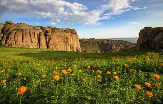
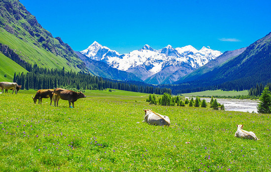
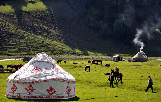
Jiangbulake Prairie is a Kazakh language, meaning the source of holy water. She gathered the aura of the Tianshan Mountains, and incorporated many beautiful legends. Here, the distant mountains near the water set each other off, the forest and snow peaks blend, green waves and flowers like tide, a holy natural scenery. The beautifulJiangbulake Prairie attracts the attention of many visitors with its beautiful and charming scenery, including the beautiful and quiet black waterlogging dam, the most Tianshan slope in the world, and the idyllic scenery across the fields.
It is a perfect combination of vertical integrated mountain landscape in typical temperate arid areas and unique mountain wheat field prints. It is the continuous landscape of tianshan World Natural Heritage site in Xinjiang, and has been identified by the Chinese Academy of Sciences as one of the earliest oasis cultures of the most complete protection. Scenic spot resources huge entity, rich species, formed by farming culture, the culture, nomadic culture and so on nine big culture for background, to sightseeing photography, leisure, scientific research, popular science education, hiking adventure, kang fitness as the main function of characterization, quality, compound international leisure holiday scenic area, is the Xinjiang "tianshan li golden line" one of the core, known as a natural oxygen bar, green kingdom, photography, hiking paradise, is a Shenxianland under the tianshan arms.
Itinerary
Driving across the Tianshan Mountains in the Mushan road, there are many small wild animals along the way to attract people to stop.
In addition to the thousands of acres of wheat fields all over the hills seem to be in a European town, there is a magical strange slope of the Tianshan Mountain, riding on the downhill slope without effort. There is also the most famous symbol-"knife pick ridge". Between the extended snow-capped mountains, there is a high snow-capped mountain, in a long strip, standing like a blade, so the local herdsmen call it "knife pick ridge".
kindly reminder:
1、Jiangbulake Prairie scenic spot is at the top of the mountain. Before entering the scenic spot, watch the weather changes and be ready to add coats around you
2、If you want to ride a horse in the scenic area, please say the price and time in advance before riding the horse. Please do not walk behind the horse so as not to cause safety problems.
Day 4 Qitai-Keketuohai (about 300KM)
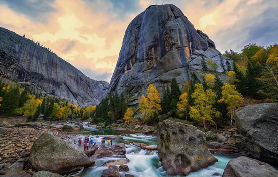
Today's attractions: Keke suri
It is one of the main scenic spots of Keketuohai National Geopark, 23 kilometers away from Fuyun County, Hoh Xil Lake, also known as Wild Duck Lake, with an area of 2677 mu, an average water depth of 2 meters, and more than 20 floating islands formed by staggered reeds in the lake, rich in aquatic plants.
Keketuohai National Geopark
Keketuohai National Geopark(namely Ertyses Grand Canyon Scenic Spot) is the source of the Ertyses River, a famous river in northern Xinjiang. The scenic spot is about 20 kilometers long, among which there are more than a dozen scenic spots such as birch forest, Shuiditch, Shenzhong Mountain, and hot spring, all along the Ertyses River. There are interval cars in the scenic area, which is a round-trip ticket from the scenic area gate to Shenzhong Mountain (17 kilometers one way). Intercars operate in a way similar to a bus, with a few stops in the middle, tourists get off to visit the surrounding scenic spots and then wait for the next car. There is still 6.5 kilometers away from the hot spring in the deep canyon. You need to go on foot. If you do not have enough physical strength, you can also take the patrol car in the scenic area.
In the gate of the scenic area to Shenzhong Mountain a section of the more key scenic spots are birch forest, water mill ditch, Hongye ditch and Shenzhong Mountain. There are also a lot of strange peaks and rocks along the road, in the middle of the Ertysh River is clear and magnificent, you can have a good play.
Itinerary
Starting from the hotel, along the G216 national Road to Fuyun County, the Gobi scenery is also an indispensable beauty along the way.
Arrive in Keke suri Scenic area, punch in and take photos, and go to Keketuohai Town.
Arrive at Cocato Sea Scenic spot. It takes about 10-15 minutes from the parking lot all the way to the ticket office, and the interval car takes about an hour. Get off at the end of the interval car and return to the original way. There is a battery car beside the bridge below Shenzhong Mountain, and you can walk another 3 kilometers into the canyon. This fee is not included in the interval ticket of the scenic area, so you need to buy a ticket here alone. Do not take the battery car can play in the river, or next to a mountain mountain play. Pay attention to safety along the way. After the original road back to the parking lot to take the interval car to the entrance of the scenic spot.
kindly reminder:
1. Large temperature difference between morning and evening, Take long-sleeved clothes with you. Suitable for light hiking, to wear comfortable shoes;
2.216 national Road speed limit, driving time is long, please bring snacks and fruit;
Day 5 Keketuohai-Hemu (4 about 60 KM)
Today's attractions: Hemu
Hemu River flows from northeast to southwest, natural and primitive mountain scenery, primitive village and the prairie harmonious and natural integration. When we come to Hemu Village, the first thing to enter our view is the small cabins and groups of herds, together with snow peaks, forests, grassland, and constitute a unique natural and cultural landscape with blue sky and white clouds.
Its significance is that these cabins have become the symbol of the Tuva people. Most of the cabins are buried in the soil to resist the cold of the snow for nearly half a year, which is particularly primitive and simple, and has the traditional characteristics of nomadic people. The roof is generally nailed with wood adult type canopy, the room body with a diameter of 30 centimeters of 30 or a single layer of log pile, both warm and moisture-proof.
On the hillside around Hemu Village, you can overlook the panoramic view of Hemu Village and Hemu River, view the sunrise, snow peaks and trickle streams, and visit the Tuwa family. It is the best place to shoot the sunrise, morning fog, wooden house and Hemu River.
Itinerary
From the hotel, all the way north to Hemu Village, timely lunch along the way. Along the way, flocks of cattle and sheep, blue sky and white clouds of the grassland, are all people always want to stop involved.
After arriving at the gate of Hemu Scenic area, change the interval car to enter. Although you can not stop to take photos, the scenery outside the window will let people experience the beautiful scenery is always three points in the scenic spots, seven points on the road.
First find the home stay, put down your luggage, you can go to the viewing platform to overlook the whole village. The fastest return time is about 2 hours. You can also enjoy free activities in the river and birch forest to enjoy the lazy leisure time of the wood.
kindly reminder:
1、 On the day of the whole mountain road, carsickness tourists must pay attention to prepare medicine in advance
2、 The scenery along the way to the scenic area is infinitely good. If you need to get off to take photos and punch in, please communicate with the master in advance, and find a safe area to stop before getting off. When you need to cross the road, please pay attention to the passing vehicles and pay attention to the safety on the road.
3、 Due to the remote location of Hemu Village, the prices in the scenic area will be relatively high than those in the city. Please prepare the required items in advance.
4、Hemu Village is mainly wooden homestay or wooden villa, can choose to stay limited, need to have psychological preparation in advance.

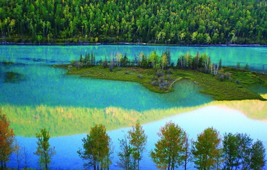
Day 6 Hemu-Kanas (about 100KM)
Today's attractions: Kanas
With the majestic scenery of the north, and the beauty of the Jiangnan landscape, in addition, there are "sea of clouds Buddha light", "color lake", "float wood long dike", "lake monster" and other beautiful scenery, how can not be called the western regions of the beautiful scenery, Shenxian scenery. To the north is the snow-covered Kuitun Mountain, the towering Friendship Peak. Around the lake, the mountains, the mountains like a painted screen. Different plant communities have distinct layers and different colors.
Itinerary
By interval car into the kanas scenic area, through kanas famous three bay "Shenxian bay, moon bay, wolong bay" to the Shenxian bay water become sparkling, like flashing pearl necklace, then arrived at the moon bay, overlooking the like a huge footprints in crescent river, and then to wolong bay, like the sword in the Jurassic park, lying in the middle of the river
You can walk in the ancient Kanas Tuwa village, also can go to the Kanas Natural Reserve by car, in the peaceful and mysterious, beautiful Shenxian tale world, temporarily put down the anxiety of city life, meditation eyes, open arms to embrace the quiet and empty here.
kindly reminder:
1, there are many mountain roads, please carsickness tourists must pay attention to prepare carsickness medicine in advance;
2,To enter the Kanas scenic area, you must transfer to the regional car in the scenic area, because the interval car is a cycle, there are many stops along the way, in order to facilitate sightseeing, it is strongly recommended to carry the items needed that night, light to enter the scenic area, large luggage temporarily on their own tourist car;
3, In order to facilitate you to have more tour time in the scenic area, so regardless of the cost of special accommodation in the scenic spot, but due to the poor local infrastructure and environmental requirements, the accommodation conditions in the scenic area are poor, please make psychological preparation in advance;
4,There are still many local residents living in the scenic area, please do not tease cats and dogs, stay away from animals. When communicating with the local residents, please respect the local customs and habits.
5,According to the regulations of the scenic spot, hiking is not allowed, and smoking is not allowed. Please cooperate。
Day 7 Kanas-Burqin (about 180KM)
Today's scenic spot: a fish viewing platform
The fish Pavilion is located on the top of a mountain near the lake, 700 meters relative to the lake. It takes about one and a half hours to climb the artificial stone ladder from the lake. After the view of the fish pavilion, there is a dirt road to reach the top of the mountain, but there is no feeling. Part of the fish pavilion hangs in the middle of the summit, but this half is the most critical position to look at Kanas Natural Reserve.
Itinerary
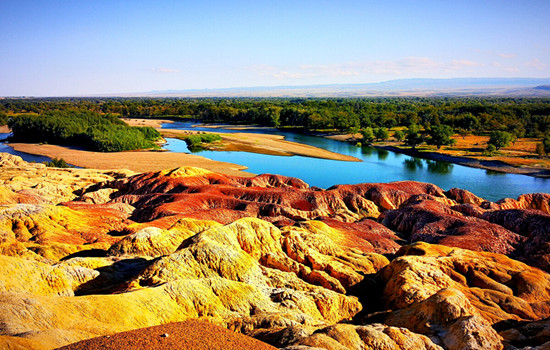
Go to the transfer center to take the interval bus on the fish platform. On the view of the fish platform, go up the mountain to see the lake, down the mountain to see the scenery, enjoy the highlight of the Kanas central scenic spot!Return from the transfer center to the gate of JiadValley Scenic area, and return to Burqin for the tour bus.After returning to Burqin County go to Wucaitan Scenic area, which is located in the arid and windy area, due to the riverbank rocks。
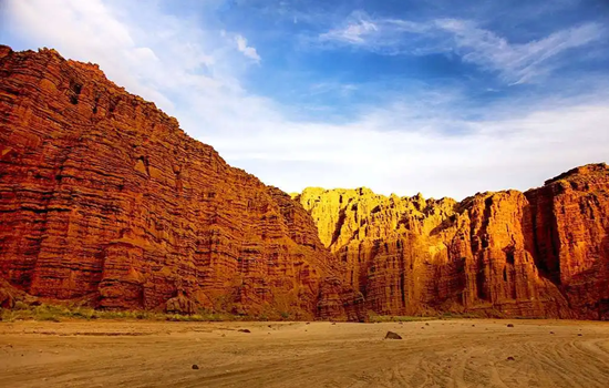
The strength of weathering resistance is different, forming an uneven outline. The rock layer is composed of red, earth red, light yellow and light green sandstone, mudstone and conglomerate. The rock has different colors, colorful, such as colorful castles, monsters, peaks and other strange landforms, which is a typical colorful hills. When the wind rises, it will make a strange sound, adding a mysterious color.
kindly reminder:
1. Please take your belongings to avoid losing them.
2. The sunset time of the Five Colors Beach varies with the season. If there is no sunset, the weather may not be able to watch the sunset, please prepare psychologically in advance.
Day 8 Burqin-Jimunai (about 200KM)
Today's scenic spot: Jimunai Stone Shicheng Geopark
The granite landform in the park is rich and typical, it is a dry area in China, with a large scale and a "god" shape. It is a granite rock egg landform landscape area dominated by wind erosion. It has a variety of micro-landforms, such as granite egg landform, stone egg piling landform, stone mound, stone cave, stone cave, stone basin, stone forest, stone column, stone trough, cliff and so on, and can be called the museum of granite wind erosion landform.
Itinerary
To Jimu is Shenshi City Geopark, the park not only has mysterious grassland stone figures, there are many different forms of granite landforms, is currently rare in the northern Xinjiang minority scenic spots.
kindly reminder:
1. Today schedule arrangemant is free.
Day 9 Jimunai-Karamay (about 400KM)
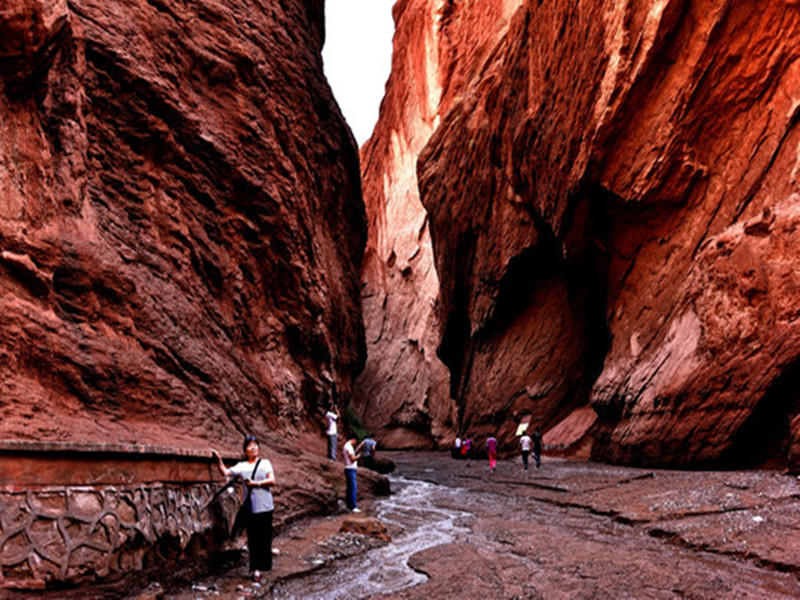
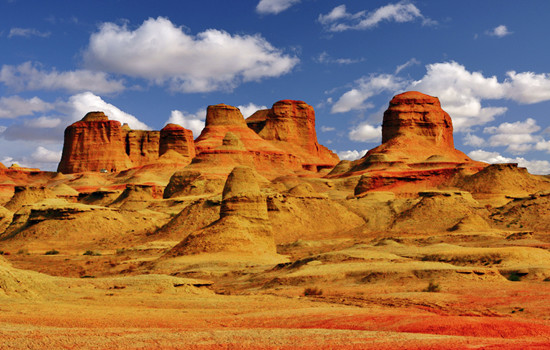
Today's attractions: Ulhe Devil's City
Ulhe Devil City, also known as Uerhe Wind City, 100 kilometers away from Karamay City, is a unique wind erosion landform, strange shape scenery makes the local Mongols call this "SulumHak". The Uighurs called it "Shayi tank si", which means where the devil lives. In fact, here is a typical Yadan landform area, in the northwest, east and west, the length and width of about more than 5 kilometers, a radius of about 10 square kilometers, the ground is about 350 meters above sea level.
According to investigation, about one hundred million years ago in the Cretaceous, here is a huge freshwater lake, shore with lush plants, water habitat breeding ur wo, plesiosaurs, dinosaurs, junggar pterosaurus and other ancient animals, here is a aquarium gathered "heaven", then after two big crust changes, the lake became sandwiched between sandstone and mudstone land vast, geology called it "gobi platform".
Itinerary
Urhe devil city, appreciate the Yadan landform, naturally formed a variety of pictographic attractions, three points by looking, seven points by thinking.
Along the G217 national Road to Karamay, through the observation platform of BaijiBeach area, you can see the dense oil production machine standing in the vast Gobi Desert, as if entering the movie scene of science and technology blockbuster.
kindly reminder:
1. Strong windy, hot in summer, has avoided the midday sun, but the climate is dry, pay attention to sunscreen and water; please prepare for sunscreen and heatstroke in advance.
2. The observation platform of Baili oilfield is the oil production area of the oilfield, and fireworks are strictly prohibited.

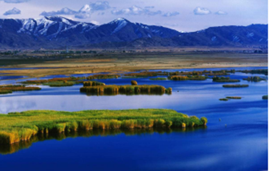
Day 10 Karamay-Sayram Lake (about 350KM)
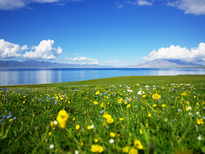
Today's attractions: Sayram Lake
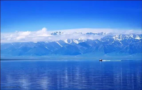
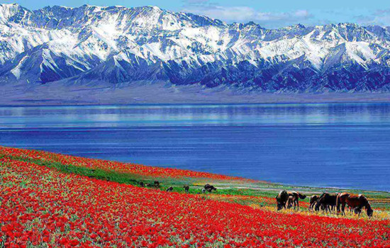
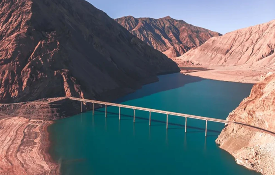
Sayram Lake, known called "Net Sea", is located in the North Tianshan Mountains in Bole City, Xinjiang Province, close to Huocheng County, Yili Kazak Autonomous Prefecture. The lake is 2071 meters above sea level, 30 kilometers long from east to west, 25 kilometers wide from north to south, an area of 453 square kilometers, the water storage capacity of 21 billion cubic meters, the water is clear and transparent to 12 meters.
Itinerary
Follow the G30 expressway to Sayram Lake ,arrange lunch in the east gate service area of the scenic area.You can take photos and punch in the Sayram Lake scenic area, stop and enjoy the leisurely time. Summer cerimu Lake wild flowers in full bloom, you can sit on the ground by the lake and meditate, you can also ride on the grassland. At this moment, time can stay in the camera, can also quietly disappear in the casual laughter.
kindly reminder:
1. Sayram Lake has a high altitude and the weather changes quickly. Please prepare sunscreen, wind and cold prevention equipment in advance.
2. The scenic area is located in a remote area, with high prices and accommodation conditions are limited. Please make psychological equipment in advance.
3. There is a natural hot spring water in the Wenquan County hotel.
Day 11 Sayram Lake -Yili (about 150KM)
Today's scenic spot: fruit ditch
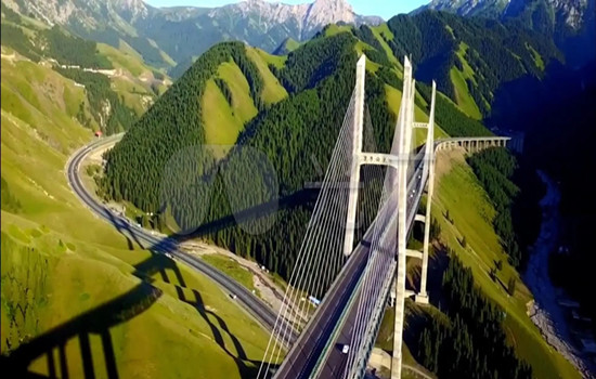
Guogou is known as the "first scenery of Yili". It is located in the pass of the western Tianshan Mountains and is the throat into the Yili Valley. It has been known as its dangerous location since ancient times. The ancients wrote a poem praising its "landscape strange, match for Guilin, cliff stone strange, better than Yanyan". In spring and summer, it is the most beautiful valley in western Xinjiang, which lasts from late May to September every year. Any slope on the fruit ditch can capture the forest belt and ridge boundless layers.
The Guogou Bridge here is the longest road bridge in Xinjiang. The bridge starts from the Guogou Tunnel, passing through the mountains and finally reaching the national Highway 312. Here, you can enjoy the spectacular bridge architecture and steep valley scenery, as well as experience the grandeur and grandeur of the bridge.
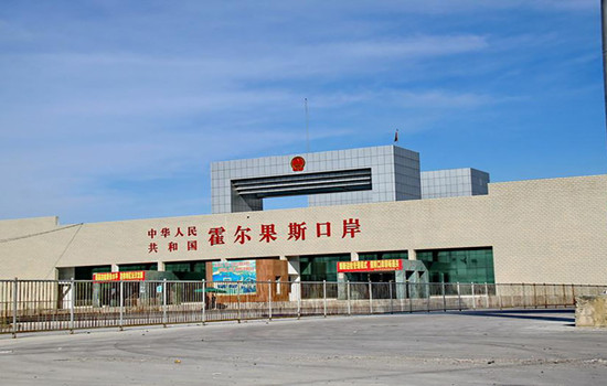
Khorgos port
Khorgos port is the longest national first-class land road port with the largest comprehensive traffic volume, the best natural environment and the most complete functions in the history of western China.
As early as in the Sui and Tang Dynasties, Horgos was an important post station on the New North Road of the Silk Road and an important channel for transportation in the Western regions. In the seventh year of Guangxu (1881), China and Russia signed the constitution of Land Trade, and Khorgos became the official treaty port between China and Russia.
Itinerary
Through the first scene of Yili-fruit ditch, on the way you can enjoy the fruit ditch bridge built between the mountains,After arriving at the Khorgos port from 12:30 to 17:30, the old Guomen scenic spot punched in the boundary monument between China and Tsarist Russia in the Qing Dynasty. After that, you can get a pass to enter the duty-free zone, which has not only many goods from Chinese exports, but also special goods from other Central Asian countries such as Kazakhstan.
kindly reminder:
1, Guogou Bridge is the only place on the way, the bridge can not stop, can only drive slowly slowly experience the steep here;
2. There are many goods in the duty-free area of Khorgos port, which is not a shopping store.
About lavender viewing
3. Every year from mid-June to mid-July is the lavender blooming season, the flower season we will specially arrange to go to the lavender flower field today to take photos and watch, to meet your yearning and love for lavender;
4.Smokey base for free scenic spots, do not go to no refund, the flower season will be automatically cancelled, without any cost increase or decrease, please know;
5. Due to the visit to the lavender base, today's travel time node will be slightly adjusted according to the actual situation.
Day 12 is Yili
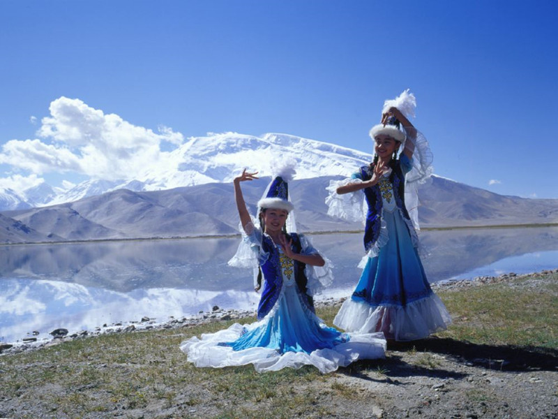
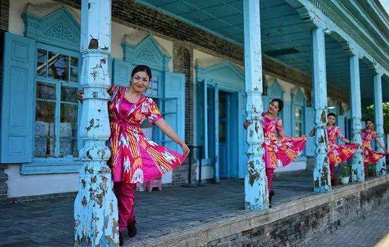
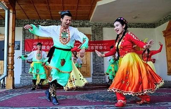
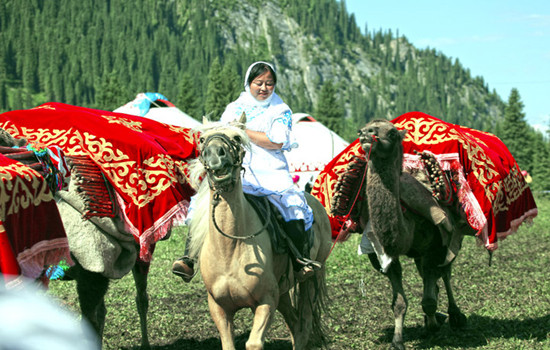
Kazan qi folk tourist area
Yili city to praise its folk tourist area is the only one in northern Xinjiang Uighur ethnic customs as the main body of the large original ecological cultural scenic spot, because it is the window of Yili city image, is also the reality of ethnic customs, it covers the thick Uighur culture, and do not break the northern Xinjiang Uighur national unique folk customs.
For foreign tourists, it is enough to meet their desire to "run in a carriage city" and "feel the ancient traditional folk culture in a modern city". Here still retains the original Uyghur traditional way of life: antique Uyghur dwellings; poetic bridge; tall and simple poplar, mellow milk tea, exquisite cakes, classical, traditional, lively Uyghur wedding; bold, cheerful, warm...
Itinerary
Yili City Kazan its folk tourist area characteristics of the Uygur traditional buildings, not only experience different folk customs, there are many special food waiting for everyone!Six Star Street, the rise of Internet celebrities in recent years, has witnessed the strange cultural symbiosis phenomenon of the combination of foreign culture and local culture.According to the actual time back to the hotel, after a day of rest, let the tired body and mind get relieved to continue the happy journey!
kindly reminder:
Today in the city can follow the tour bus to go, can also be free activities, is a little rest of a day!
Day 13 Yili-Zhaosu (about 300KM)
Today's attractions: TheXiata Valley
In ancient times, it was a transportation post from Yili to Aksu. The Shata River flowed out from the mountains, opened the flat grassland and flowing into the vast Teks River. Shata Canyon to the river by the mountain pass, ancient road, ancient sites, folk customs and natural landscape, formed an ancient cultural landscape. It is also known as the Tang Monk Ancient Road, and it is said that this is the famous "Gongyue Road" of the Tang Dynasty. The "Ling Mountain" that Tang Xuanzang crossed to the west is here. It is the most precipitous passage on the Silk Road. Along the canyon, it is the remains of the ancient road.
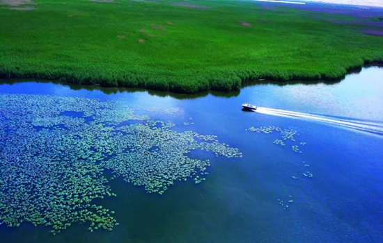
Tianma Wetland Park
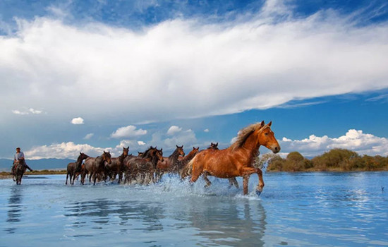
Located in the Zhaosu River Basin, it is the largest natural wetland in Xinjiang and the largest wetland park in northwest China, covering an area of nearly 5,000 hectares. There are various types of wetlands, including swamps, lakes, rivers, etc. The wetlands have rich natural resources and unique ecological environment. And it is known by visitors, in the scenic area of the "Tianma bath River" performance.
This characteristic continues to this day, Zhaosu County is known as "the hometown of Tianma in China" because of its rich "Tenglun, western pole" horses. Every summer, herdsmen will bring their horses to the Tex River every day to drink water and run. As time goes by, "Tianma Bath River" has become a unique scenery in the wetland park.
Itinerary
Crossed the Tianshan Canyon along the way, and deeply felt the many canyon scenery of the Yili Valley.
Arrive at the Shata Scenic area, and transfer to the Shata Canyon. The primeval forest deep in the Tianshan Mountains and the mountain grassland are a unique scenery.
The "Tianma Bath River" performance in Tianma Wetland Park will be a special web celebrity punching place for many visitors to visit.
kindly reminder:
1. The interval cars in Shata Scenic Spot are circular trains, and electronic tickets need to be booked in advance in peak season.
2. The Tianma Bath River performance should control the time of arrival at the park. It may be impossible to watch the performance due to objective reasons such as weather changes and missing the performance time.
Day 14 Zhaosu-Qiongkushtai (about 170KM)
Today's attractions: Qiongkushtai
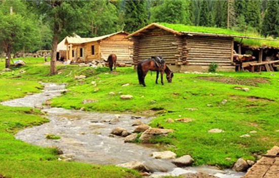
Qiongkushtai is a pastoral village with more than 300 households and more than 1,700 people, and the village residents are mainly Kazakh. The village is surrounded by mountains, the houses are built by water, and the Courdai River flows all the year round. The buildings of the village are mostly round wooden structure, which is a well-preserved wooden building complex in the Ili River Valley. It has high historical and cultural value and is gradually attracting more tourists to travel for vacation.
Itinerary
On the way to Qiongkushtai, the alpine meadow and grassland under the blue sky and white clouds are all the beauty of the computer desktop.You can stroll around the village, or ride horses or go to the Wusun Ancient Road. Even staying quietly in the wooden house is a quiet enjoyment。
kindly reminder:
1. Qiongkushtai Folk Village was originally a fixed residence of Kazakh ethnic compatriots. The wooden houses and homestay here are similar to those of Hemu Village, and the living environment is far from that of the city.
2. If you need to ride along the Wusun Ancient Road, please choose the regular horse team in the village.

Day 15 Qiongkushtai -Tex (about 100KM)
Today's attractions: Karajun
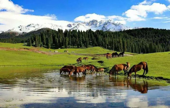
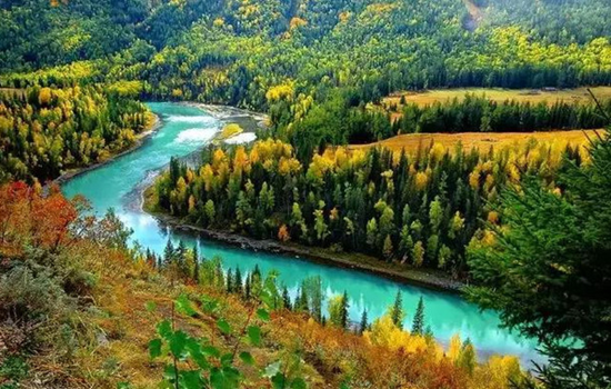
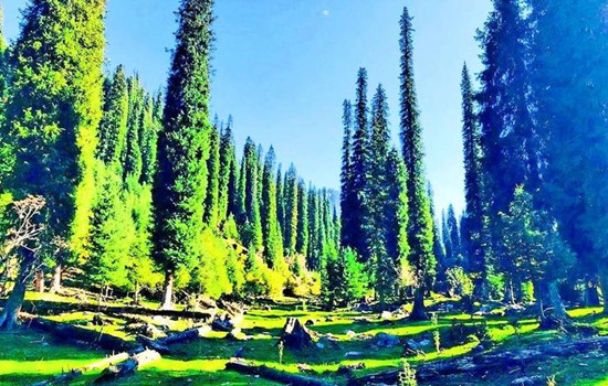
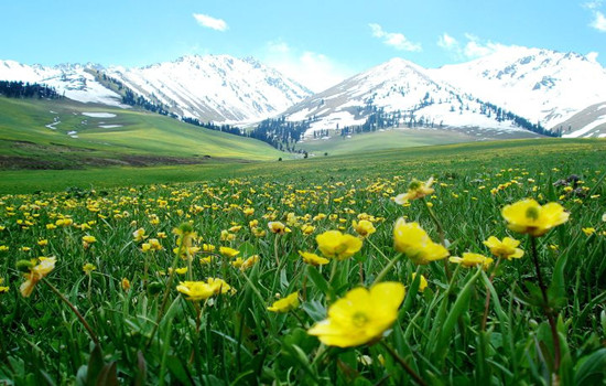
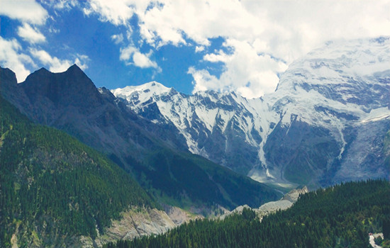
"Karajun" is a Kazakh language that means "the wilderness on the ridge". Kaljun mountain is a east-west rolling mountain, it is flanked by the gully comb mountain, ups and downs, the growth of dense primitive spruce forest. Between 2000 and 3600 meters above sea level, it is an alpine meadow grassland, which is about 25 kilometers wide from north to south and more than 40 kilometers long from east to west, with a total area of more than 1000 square kilometers. It is the most beautiful area of Tianshan grassland, completely retaining the original and pure natural appearance, grassland and forest blend, snow peaks and valley reflect, the scenery is very spectacular, showing the original beauty of snow ridge spruce.
Khoksu Grand Canyon
The Kuoksu River twists and turns, forming the nine curves of over 5,600 meters long from north to south and more than 2,000 meters wide from east to west. Herdsmen's yurts are dotted with them, gorge scenery, waterscape, mountain scenery, tree scenery and other natural landscape, full of fun.
Itinerary
Kuoksu Grand Canyon includes Jiuqu Eighteen Bay, Kuoksu Grand Canyon and Crocodile Bay, and finally from the Kurdai River cableway into the Kaljun Grassland Scenic Spot.
Transfer to the interval bus and start to visit the Karajun scenic area. The flower platform is an excellent place to enjoy the beautiful scenery of the grassland. After getting off the bus, climb uphill along the plank road. Although it is a little laborious, you can see the snow mountains, forests, flowers and grasslands here, and you can also take photos with the lamb.Falcon platform: a traditional hawk place for local people. After getting off the bus, it is recommended to go about 1 km along the plank road (also on horseback), overlooking the "three-level level plane" and forest canyon.
After staying at Tex County Hotel. You can also go out of the scenic spot in advance to the exit street and Bagua Park in Tex County, and feel the many marks of the I Ching culture in this characteristic county。
kindly reminder:
1. The interval car circulation system in the scenic area, so please listen to the master explain whether to get off at each stop.
2, each stop has a canteen, only in the ropeway station below a restaurant can eat on the way.
Day 16 Tex-Donbra (about 160KM)
Today's attraction: Kuronin
Kuronin is the Kazakh language. The grassland scenic spots in Yili are located in the east-west valley, but Kuronin is in a north-south mountain valley, about 14 kilometers long, about 1 km, the average elevation of the valley 1500 meters. The special trend makes Kurdistan warm in winter and cool in summer, and the climate is pleasant in the four seasons, so it combines the charming and beautiful scenery of the south of the Yangtze River and the broad and rugged grassland scenery, attracting more and more tourists from home and abroad. Her stunning appearance and extraordinary natural landscape is breathtaking, make people infinite yearning.
Itinerary
The scenic area also has many stopping points in the area, which can determine the length of parking in each scenic spot according to the actual situation. Choose the dining place in real time in the scenic spot, and you can also bring your own dry food to enter the scenic spot.
kindly reminder:
1, changes in mountainous areas the weather changes quickly, pay attention to the weather changes at any time and decide the time of stay.
2, more winding mountain road, please prepare carsickness medicine in advance.
Day 17 Tangbra-Naraty (about 160KM)
Today's attraction: Naraty
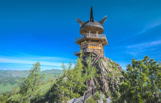
Naraty tourist scenic spot integrates grassland, valley and forest, with high vegetation coverage rate and rich wildlife resources. Because of its unique natural ecological landscape and cultural landscape, it is known as "Tianshan Green Island", "green home" and "colorful grassland". The main scenic spots are Tianjie Platform, nomadic family, Tusani (meaning "beautiful valley" in Kazakh), Sendai, Wall Tower observation platform, Snow Lotus Valley and so on.
Itinerary
Enter the Naraty grassland scenic area, looking for the rich beauty of the beekeeping women. You can overlook the beauty of the whole valley grassland, but also go to the snow lotus valley and snow mountain close contact, feel the cool summer.
kindly reminder:
1. For example, under the opening of duku Highway in summer, take the middle section of duku Highway G217 to Naraty town.
2. Nalati Airland Grassland is located in a mountainous area, please always be ready to add clothes.
Day 18 Naraty-Yili-Kuqa (about 90KM)
According to the actual time return to Yili city, according to the actual flight time to Kuqa.
kindly reminder
1, Different seasons may go to Kuqa ticket time is different. It could be that night, or the next morning.

Day 19 Yili-Kuqa (about 220KM per drive)
Today's scenic spot Tianshan mysterious Grand Canyon
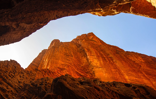
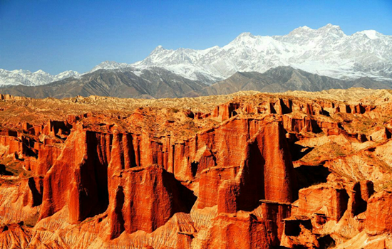
The mysterious Grand Canyon is in the landscape of Kizilla, one of the nine film and television bases in China. The huge red mountain group was formed in the Mesozoic Cretaceous period 140 million years ago, after millions of years of wind and rain erosion, flood erosion, forming a crisscross, orderly ridge and groove, far look picturesque, like "Potala Palace", Shenxian day Qiongge; close look like people like things, like a dream, lifelike, charming. It is uncanny workmanship, the wonder of heaven into the lament.
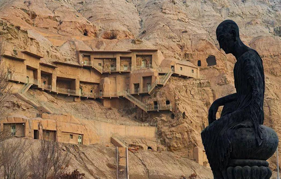
Kizil Thousand Buddha Caves
Back mingwu TagMountain, facing the Muzat River in the south, during which the Weigan River winds through, about 69 kilometers from Kuqa county in the east, belongs to the territory of the ancient Qiuci State. It was dug in about the 3rd century and gradually stopped building in the 8th and 9th centuries. As of 2019, there are 236 grottoes with more than 10,000 square meters of murals.
There are two kinds of caves in Kizil Thousand Buddha Cave: one is a place for monks to live and produce, mostly with living kang and simple living facilities; the other is the Buddhist temple, which is a place for Buddhists to worship and lecture. The temple is divided into the giant Buddha grottoes with tall grottoes, open grottoes, the main wall of the Buddha, and the central columns, and some of them are the square grottoes with more regular grottoes. Different shapes of caves have different uses.
Itinerary
Visit the mysterious Kuqa Grand Canyon National Geopark, where the valley side of the rocky peaks, competing to rise; overlapping peaks, sky, cliff, majestic magic. The scenic area depends on hiking and must go back, according to their own actual situation, pay attention to control the round-trip time.
As one of the four major grottoes in China, Keizil Thousand Buddha Cave is the most intact grottoes with the largest open area in Xinjiang.
kindly reminder
1. Tianshan mysterious Grand Canyon scenic area should pay attention to the safety of the foot, are gravel road, wear convenient walking shoes are more suitable; some places have limited traffic conditions need to queue through, walk without seeing the scene.
2. If the Kuqa Grand Canyon National Geopark is prone to flood in rainy days, please follow the management of the scenic spot and refund the tickets when you cannot visit it.
3. Salt ditch section parking photos must stop in a safe area, should be careful when crossing the road.
4. If you need to detour to the garage during the prohibited period of the single library highway, the scenic spots on that day can be postponed to the next day, or the individual scenic spots can be cancelled through friendly negotiation.
Day 20 Kuqa day tour
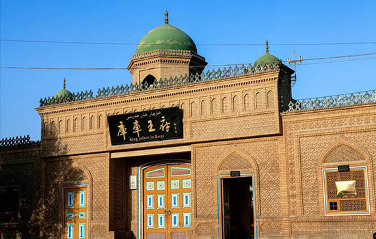
Today's scenic spot: Kuqa Palace
There are Qiuci Museum, Kuqa Palace cultural relics hall, Kuqa folk custom exhibition hall, the last "Kuqa king" official Tai Qing Dynasty city wall and so on. Visitors can learn about the 190 years of the hereditary "Kuqa King" through the exhibition of cultural relics, family history and special diet.
Kuqa Palace is a large area, about two or three hundred meters, there are many buildings inside, most of the buildings are Uyghur style, colorful interior, you can take photos everywhere, there are gardens and green space in the courtyard, the environment is very good. The palace visit is divided into three places: the Qiuci cultural exhibition area, the Wangfu visit area and the old city wall. After entering, you can walk to visit, generally about 2 hours is appropriate. The Qiuci cultural exhibition area shows the cultural customs of Qiuci country in the history of Xinjiang. There are many text and pictures, the precious cultural relics of Qiuci Buddhism, and the production tools, coins and folk handicraft relics of the ancient country.
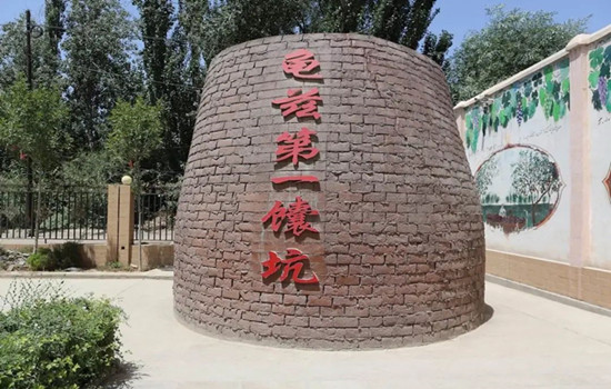
Kuche big nang city
It is not only a concentration of naan production and sales, but also a 3A level folk customs tourist area. As an intangible cultural heritage of the autonomous region, Kuqa Da Nang enjoys a national reputation for its large and thin, crisp and fragrant characteristics. Kuqa Nang City covers an area of 20,000 square meters, divided into three parts: affordable residential areas and commercial areas and naan culture exhibition area, among which the commercial district has naan culture exhibition hall, folk characteristic catering area, naan production workshop, naan exhibition and sales hall, etc. There are special food, big naan culture exhibition hall, mass culture stage, is the Kuqa County strive to build the propaganda and cultural base, characteristic catering base, employment and entrepreneurship base.
Itinerary
Today is a day to rest, sleep to wake up to visit scenic spots, free day!
The old city wall of Kuqa Palace is an ancient building in the palace. You can have a simple look. In the scenic area, there is also the original display area of the former Wangfu, and there are displayed items used by the Kuqa king of all dynasties. Through wax figures, the life scene of the former Wangfu family is restored, and you can visit one by one to feel the living atmosphere of the former Kuqa king
Kuqa Nang City is an ancient city building selling big naan. There is a large naan at the gate of the city to take a group photo, the wall inside and outside, the ceiling and so on are the decoration of big naan, which is instantly wrapped with rich Xinjiang culture of naan.On the first floor is the music square. Many local aunts sing and dance with them, which is also an immersive opportunity to experience the local customs. The second floor is the place where Nang is sold. The factory workshop is transparent. You can see the whole process from kneading flour to baking Nang. The old tea house is also on the second floor.
kindly reminder:
1. If you do not follow the group activities on that day, you should explain to the accompanying driver in advance.
Day 21 Kuqa-Alal (about 260KM)
Today's scenic spot: Shaya Devil forest
The devil's forest is on the edge of the Taklimakan Desert, where the soil is soft sand, walking through the woods, sometimes the whole foot into the sand. Here, you will have a strong sense of thirst, the color is also a single earth gray, only to look carefully, to see a red willow or two scattered on some raised sandbags, showing a little green.
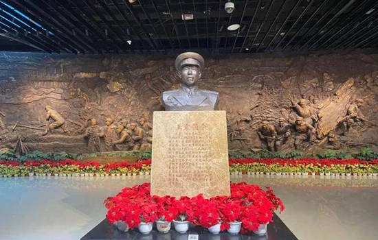
Military reclamation museum
Its content to the hero of the red army and the eighth route army 12 O brigade revolution history, the construction of the Xinjiang production and construction corps history as the main line, through the physical, pictures, sound and photoelectric multimedia, relief, sculpture scene, detailed and comprehensive show the troops from the red army period, to bay production, fighting, to the liberation of the northwest, troops in the tianshan north and south field, forest land production, driven by bay spirit, promote each enterprise vigorous development, four civilization construction achievements, agricultural modernization leading the national agricultural development, etc.
This museum is one of the most worthwhile museums in Xinjiang.
Itinerary
There are many dead poplar trees in shaya Devil Forest scenic area, which is the product of the Tarim River riverbed diversion, and few tourists in the small scenic area can play slowly.
You will pass a large area of poplar forest. Standing at both ends of the Tarim River bridge, you can take a beautiful scenery of poplar.
Military Reclamation Museum is also the 359 Brigade Reclamation Culture Memorial Hall, with a construction area of 11,000 square meters. The museum shows the legendary entrepreneurial history and struggle history of the 359 Brigade, and introduces the process of the corps army reclamation people to support the building and reproduce the civilization. It is a monument forged by several generations of army reclamation people with blood and sweat, and is a famous red tourist attraction. What I see here is not only a museum, but also a history book of the development of the Xinjiang Production and Construction Corps.
kindly reminder:
1. There are many mosquitoes in the forest. Please prepare mosquito repellent water in advance. Ultraviolet light is strong, pay attention to wind, sunscreen and water supplement.
2, the devil forest scenic area dry little rain, strictly prohibited fireworks.
3. today the journey is far, can take some snacks, fruits, etc., with enough water, along the way to buy along the way;
4. If the Army Reclamation Museum closes on Monday, the trip will be cancelled.

Day 22 Alal-Khotan(about 420KM)
Today's attractions:
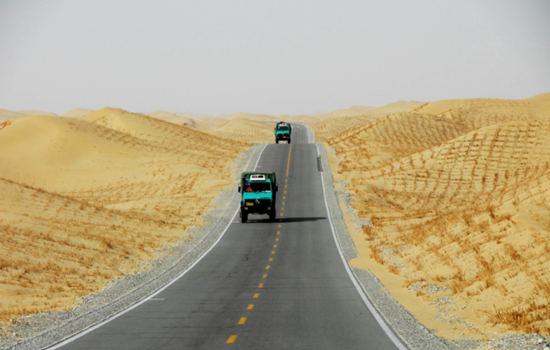
Desert Highway
The Tarim Desert Highway is located in the center of the Tarim Basin in southern Xinjiang. It is the largest desert in China and the second largest mobile desert in the world, second only to the Sahara Desert. It is known as the world's first "green corridor of desert".
The road is like a long black dragon cruising in the vast expanse of sand sea, rolling along the low ground of the sand dunes, becoming a unique landscape in the Taklimakan Desert.
Kashgar Yulong River
Starting from the Kunlun mountains and the Tarim Mountains, it joins and joins the Karrakash River in the west. The river is 325 kilometers long, has many tributaries, and has a basin area of 14,500 square kilometers. The river is rich in white jade, green jade and ink jade, since ancient times is the main river of Khotan jade. Also known as white Jade River, it is a river in Hotan region of Xinjiang, China.
Khotan night market
Khotan Night Market is located in Renmin West Road, covering an area of 4600 square meters, with a narrow and closed greenhouse space, a total length of 272 meters, very neatly placed according to the two sides, a total of 260 stalls, it is said that there are more than 100 varieties of food here. Here as long as you want to eat things can find, everywhere, all kinds of flavors, everything, the variety is amazing.
Itinerary
Along the desert road from Alar to Hotan all south, along the sand dunes, poplar forest, dry riverbed, desert villages, is not the same scenery of southern Xinjiang.
To the famous Kashgar Yulong River, also known as the White Jade River, see if there is luck to pick up the heirloom Khotan sheep et white jade!
You can have a rest and go to the actual time to taste the local specialties.
kindly reminder:
1. Tourists of Yulong River in Kashgar can experience the happiness of jade pickers, and they must pay attention to safety when walking on the cobblestone riverbed.
2. Khotan night Market has many delicacies, so you can choose the food suitable for your own taste.
Day 23 Khotan-Shache (about 300KM)
Today's attractions:
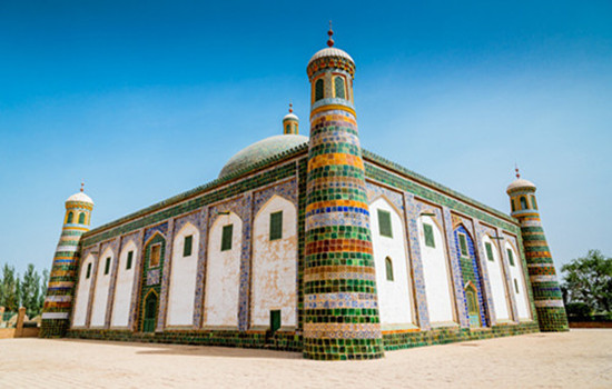
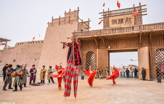
The ancient city of Jotean
The culture of ancient Yutian is the soul of the project. Based on the historical records of the ancient state of Khotan, the builders have compiled more than 700,000 words. The architectural style has basically restored the square city, the white Ayawang residence, the Sumi fort, and the Seven Phoenix Pagoda recorded in the historical books.
The city is based on folk culture and historical relics, based on the variety of traditional delicacies, handicrafts, bazaar and traditional festivals, and a combination of historical facts and story interpretation, telling the charm of the ancient city of thousands of years.
Shache Intangible Cultural Heritage Park
Also known as the Khan Palace, with blue as the keynote, thick Central Asian customs, as if through the prosperity of thousands of years ago. There are also several small exhibition halls, introducing the traditional customs of the Tajik, Kirgiz and Uygur people, as well as the exhibition halls of the Twelve Mukam, Adeles and so on.....
Itinerary
During the day, the theme of the old city is "ten party hundred plays", showing the solemn post changing ceremony of the old city, the millet caravan and the folk customs on the ancient Silk Road.
At 12 pm and 16:30 pm, 12 Muqam is a traditional Uyghur musical performance, and the performers will be invited to dance together.
kindly reminder:
1. Jotean Ancient City is a newly developed tourist attraction in Hotan area, which is very different from other ancient cities in appearance and color. Take photos and punch in to prepare brightly colored clothes.
2. There is a fixed time for davazi performance in Shar Intangible Cultural Heritage Park. If there is no plan in advance, you may miss the performance.
Day 24 Shache-Kashgar(about 300KM per drive)
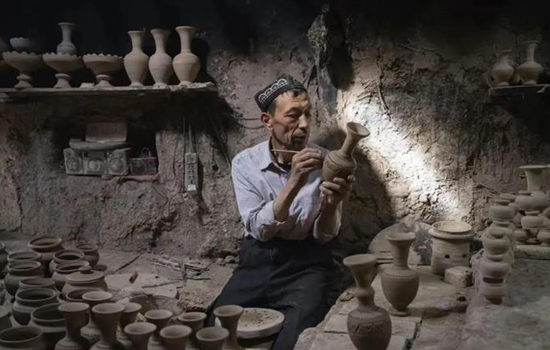
Today's scenic spot: Ingeisha Clay Pottery Village
Although Ingisha clay has been around for thousands of years, it still maintains the oldest pottery techniques. Today's clay artisans use pigments to color their clay from colored stones gathered in the Gobi or high mountains. The stones are milled, then added with rust and vegetable oil, and hand-painted with a glaze, which eventually evolves into a dazzling bright color.
Itinerary
Go to Yingji sand pottery village, known as "mud art" Yingji sand pottery, as far back as the Neolithic Age has appeared, to the Han and Jin Dynasties to develop painted pottery. Among the earthenware in Yingjisha, especially the antique earthenware is the most famous, which is bold and innovative on the basis of inheriting the traditional craft, and has the dual value of viewing and practical.
kindly reminder
1. Yingjisha County not only produces clay, and is rich in Xinjiang's famous crafts - Yingjisha knife, here is not as a tourist shopping point, if you have to buy please send home in time, can not check and carry.
2. After arriving in Kashgar, the first task is to apply for Shangta County pass with the assistance of the driver !!!!
Day 25 Kashgar-Ta County (about 300KM)
Today's scenic spot:
Baisha Lake
Baisha Lake is a scenic spot that has gradually begun to enter people's sight in recent years. Baisha lake is scattered with the white sand, and the distance around the lake is the snow-capped mountains. The whole Baisha Lake is surrounded by the surrounding snow mountains, around the tall snow mountains like a kind "mother" guarding this plateau lake, so that it will not be disturbed by the outside world.
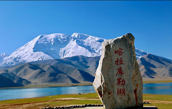
Kharakule Lake
To the east of the lake stands the "father of the glacier", the peak, to the west; the south of the lake is the grassland, a summer comes, the clear grass, the lake, green grass, a white felt dotted, and the reflection of the lake, as in the ancient poem "wind grass low see cattle and sheep". Pastoral songs on the grassland, the wild duck on the lake, this scene, like a dream, no wonder even the 10th century BC Zhou King Mu so far also sighed, feeling.
Itinerary
On the shore of Baisha Lake, there is a large area of high mountains, hills and rolling mountains. High mountain is sand mountain, sand mountain is silver white, silver white fine sand white soft, like white silk. More than 10 hills composed of the Baisha Mountain winding more than 10 kilometers. The snow light in the distance reflects the Baisha Lake, and the grass planting by the Baisha Lake reflects the Baisha Mountain.
The Karakule Lake is full of water and grass, with thousands of water birds and wild ducks swimming, and sometimes the opposite swans are playing in the water. Besides the grass beside the lake, there is no creature in the lake, especially the lake constantly changes various colors throughout the day, which is confusing.
On the way you will pass by Tahman Wetland Park. The tall willows on both sides of the road interweave into arches, leading to the front until the towering snow-capped mountains and blue sky in the distance. Driving through it, as if through the fantasy space tunnel, this inexplicable shuttle sense, only once to experience。
kindly reminder:
1. This trip will pass by Daban at the highest altitude of 4000 meters. If friends who have high anti experience start to drink Rhodiola or other preventive drugs 15 days in advance, they can also prepare oxygen bags / bottles in advance. Plateau area, please pay attention to the body, reasonable diet, avoid strenuous exercise, beware of altitude sickness;
2. Keep slow, calm, avoid fast running or other sports, and try not to drink in Tacheng. Ta County is located in the plateau, tourism reception facilities are backward, the hotel standard is low, cold prevention is not recommended to take a bath, please understand; do not close the bathroom door, if discomfort, please seek medical advice in time;
3, today's driving speed limit, the speed will be very slow, please understand more;
4. No photos or video recordings can be taken along the checkpoints;
5. Before departure in the morning, please take out the thick clothes and put them on your side. The temperature drops after reaching the plateau, and please be ready to add clothes at any time.
Day 26 Taxkorgan (about 150KM)
Today's attractions: Panlong Ancient Road
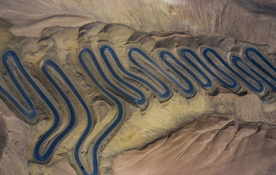
The road, named Wacha Highway, is one of the two roads leading to Wacha Township, Ta County. Although the road is difficult, it can greatly shorten the distance and the time between the county in and out of the county. Because this road is like a dragon dragon lying on the mountain, so named "Panlong Ancient Road".
The most challenging is the small pan dragon with dense curves, just like a hair card worn on the girl's head, winding, neat, as the saying goes, "today through all the detours of life, from now on life is smooth"
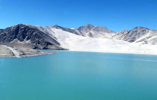
Bandier Lake
In different weather, not after time, different seasons and different light, the lake will produce different colors, sometimes may be dark blue, sometimes is light blue or Tiffany color, color diversity more than white sand lake and kara library lake, better luck, encounter no wind, the mountain on both sides of the lake will completely reflected on the lake. Very beautiful. Bandier Lake was originally a river, built as a reservoir for water storage. The lake is glacial melt water because the special minerals are blue. It is blue blue in summer and dark blue in winter.
Pamir tourist area
The Pamir tourist area includes Stone City and Golden Grass Beach.
The stone city castle is built on a high hill, and the situation is extremely steep. Outside the city, there are multi-storey or broken or continuous walls, overlapping stone hills between the walls and piles of stones, forming a unique stone city scenery. In the Han Dynasty, it was the king city of Puli State, one of the 36 states in the Western Regions. After the Tang Dynasty unified the Western Regions, there was a green here. At the beginning of the Yuan Dynasty, the city was greatly expanded, and the old stone city was changed into a new face. In the 28th year of Guangxu, the Qing Dynasty established the Bo Hall and repaired and supplemented the old castle.
Jincao Beach is on the Alar grassland below the Stone City. The construction contents include the Silk Road Castle Square, the Stone City cultural wall, performing arts square, landscape column, Naxi viewing platform, the ancient city sunset stand, the grandstand, Yongquan stand, the water platform, wooden plank road, 50 meters of breathtaking suspension bridge, sightseeing water wheel and other scenery.
Itinerary
Panlong road also known as tile just highway, total length of more than 70 kilometers, people are divided into big panlong and small panlong, including small panlong about 30 kilometers long, from 3000 meters to 4100 meters, the drop of more than 1100 meters, so the 30 kilometers of mountain road appeared 639 corners, and basic is more than 180 degrees a S bend, the road is a test for the driver. Someone joked: opened this road, other roads are floating clouds.
Bandier Lake is a free scenic spot on the road back to Ta County, quiet and beautiful Bandier blue Lake, like a blue clear plateau pearl, walking along the road beside the river, you will see a bridge on the lake, the scenery here is the most beautiful.
Although the stone city only remains, but there are snow peaks around, grass beach, rivers, and strong Tajik ethnic customs, quite rough and unrestrained beauty. After visiting the stone city to the opposite side of the road is the golden grass beach wetland, walk along the plank road while playing for about an hour to the interval bus boarding point, to the scenic area near the entrance of the Caiyun people.
kindly reminder:
1. At noon, there are some Tajik villages near Panlong Ancient Road. If you are not used to eating, it is suggested that you can bring some snacks or convenient food and go back to Ta County for dinner, so that you can taste the food well
2. The average elevation of Taxkorgan county is 3,200 meters. Note that the action is still slow on the plateau, and there are few shops entering the scenic area.
3. the sun goes down the temperature will be low, so when entering the scenic area to calculate the time, ready to add or subtract clothes at any time.
Day 27 Taxkorgan -Kashgar (about 300KM)
Today's attractions: Oyetag Glacier Park
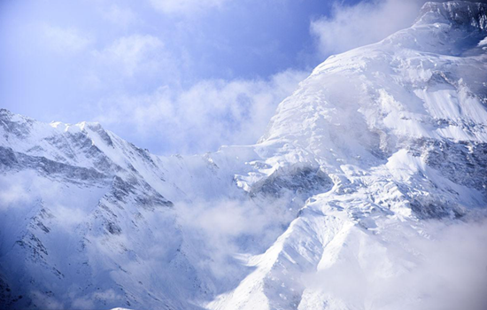
Otak Glacier Park is an ancient Turkic word meaning "a depression among the mountains". With an annual average temperature of 7.8°C, surrounded by mountains on three sides, steep snow-capped peaks, vertical glaciers and dense trees, it is praised as "the first natural ecological landscape in the Western Regions" by geological experts. The most interesting is one of the world's most rare low latitude modern glaciers in the current-Its Klaze Glacier, which is only 2804 meters above sea level, is the lowest altitude glacier in China. In summer, avalanches often occur on the snow-capped mountains above the glacier, witnessing a stunning natural spectacle from the viewing platform.
Itinerary
The snow mountains, glaciers, waterfalls, rivers, avalanche, grassland, plus herds of cattle and sheep on the hillside and the round yurt of Kirgiz herdsmen on the hillside, make this great and holy virgin land full of natural beauty, without a trace of artificial carving, everything is pure natural.
kindly reminder:
1. Oyetag Glacier Park needs to hike to the viewing platform, please do anything and pay attention to safety!
2. You need to take off your shoes to visit it. If you are clean or do not want to take off your shoes, please prepare disposable shoe covers in advance.
Day 28 A day trip to Kashgar
Today's scenic spot:
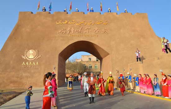
The old city of Kashgar
Strange natural scenery, rich ethnic customs, brilliant historical district road roadway, a little wider can walk donkey cart, narrow two people side by side; the street elderly more than 600 meters, short 50 meters short to the end. Streets and lanes east turn west fold, south bend north wrong, twists and turns, seemingly all the road, but then see a lane, just like All Men Are Brothers Zhujiazhuang Pantuo Road. On both sides of the roadway are a Uyghur house. The residential houses are very characteristic. Generally, people build two to three layers of civil structure on a limited plane, and some extend down and build basements. Living room and bedroom are connected by wooden escalators and stairs. Every house has a drying table, located on the flat roof. Each household has a small courtyard for growing flowers or placing bonsai. Bonsai, flowers and building pillars, wood carvings, eaves on the eaves of flowers complement each other, strewn at random, quiet and fresh. Sometimes at the junction of the two alleys, there will encounter a small building across the street, like a porch, so that the alley adds a bit of simplicity and depth. Walking up narrower and narrower alleys, walking through higher and taller houses, I came to a Uighur family in Ziliqi Lane. According to the introduction, this house is built in the top of the old block. After entering the door, the foot steps on the wooden ladder, step up, climb to the roof ridge, the eyes suddenly open, really have "see all the houses short" feeling. Even the distant tall buildings, as if only at the feet.
Apak Hoja Mazzar
The scenic spot tells the story of hometown, former residence and the fragrant princess from birth to death, from Kashgar to Beijing, from the fragrant princess to thousands of pet."Happy Apak Hoja Mazzar, love card, here, will let you deeply understand the love story of fragrant concubine. Experience Kashgar's characteristic customs and folk culture from zero distance.
Scenic area with tourist service center, sweet princess stone, sweet princess welcome ceremony, the western folk cultural center, sweet princess, folk wedding, ancient water mill, love tree, sweet princess relief wall, treasure, smell pavilion, mirror pool, orchard, oil press, kashgar old bazaar, called naan shop, sweet princess gallery, intangible exhibition, TikTok beauty base, etc.
Itinerary
You can feel the unique charm of the most famous ancient city in southern Xinjiang. See the kaesong ceremony, ethnic song and dance, eat steamed stuffed bun, eat pure handmade ice cream, go to the century-old teahouse tea... or sitting in the sightseeing car, shuttle in the crisscross roadway, leisurely, enjoy the jade, bronze, flower hat, ethnic instrument shop, the unique scenery line must make you busy.
Friends who are interested in visiting Adigah Mosque can go by themselves, and then follow the century-old street next to the mosque into the Xicheng district of Kashgar old city, and go to the century-old teahouse, Rainbow Lane, Bag Lane and other web celebrity punch points to take photos.
It is a colorful scroll; It is a touching ballad; it is a passionate legend, beauty, folk dance, love legend to welcome.
kindly reminder:
Today is the rest day. If you do not follow the group activities on that day, you should explain to the accompanying driver to arrange it by yourself in advance.
Day 29 Kashgar-Bachu (about 280KM)
Today's attractions: Bachu Red Bay
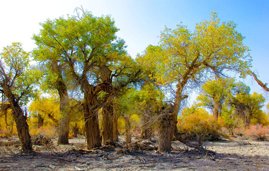
In Red Bay's natural ecological landscape is unique. Here are both the graceful and beautiful Jiangnan water towns, and the vast desert Gobi. This blue water area of the Yarqiang River basin, with lush reeds and birds flying, is a dazzling pearl on the desert oasis. Kashgar River wetland is rich in vegetation, herds of cattle and sheep, winding plank road, gurgling water, emitting a tranquil and fresh pastoral atmosphere. The 3.16 million mu of poplar forest is the largest natural wild poplar forest in the world, its uncanny form, majestic upward momentum, indomitable will, indomitable spirit, all vividly deduce the tenacious natural life, the magnificent desert scenery.
Itinerary
Bachu hong Bay is a holy place to enjoy the natural scenery and choose leisure vacation, is a window to pursue historical relics and explore the Silk Road culture, is a paradise to appreciate ethnic customs and taste special food.
kindly reminder:
1. There are few restaurants and shops in Batuhong Bay scenic area. Please prepare water and snacks before entering the scenic area.
2. Fireworks are strictly prohibited in the poplar forest.
3. If there are friends who have not finished the scenic spots in Kashgar, you can continue to play in the morning before leaving to Bachu.
Day 30 Bachu-Aksu (about 240KM)
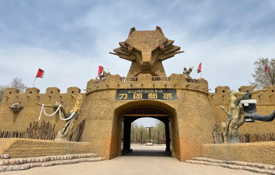
Today's attractions: The Daolang tribe
The Daolang people, the original residents around the Tarim Basin in Xinjiang Province, have been living in the isolated desert oasis and maintaining their unique folk customs. There is a folk custom exhibition hall, which you can visit and understand the story of Daolang nationality. In addition, there are vineyards, fig garden, fishing area, self-service barbecue area, farm, etc., you can come to entertainment, taste daolang food experience rich folk customs. In the east of the scenic area, the scenery is mainly poplar forest. The large area of primitive poplar forest here can come to watch the most tenacious tree species in the desert and shoot large pictures. On the south side of the east, there is a primitive village of Daolang people, which reproduces many scenes of daolang ethnic life, including houses, wooden carts, labor tools, etc., which you can go to visit.
Itinerary
Scenic area is large, length and width are nearly 1 km, after entering the scenic area can walk to play, about 3-4 hours is appropriate. The west side of the scenic area is close to the river, where there are a hundred orchards planted here. The environment is fresh and beautiful, which is very unique in Xinjiang where the Gobi is everywhere. A sand sculpture park and a statue are also built on the beach, which are suitable for taking photos. In the middle of the river, there is a water recreation area and an open-air ecological swimming pool, where you can enjoy the water. The central part of the scenic area is mainly leisure and display of daolang folk culture.
kindly reminder:
If you arrive in Aksu City early on the same day, you can play in the downtown Duolang Park or Aksu Old Street.
Day 31 Aksu- Luntai(about 340KM)
Today's attractions: Wenshu Grand Canyon
Wensu Grand Canyon is located in Bozidun Kirgiz Ethnic Township, the southern foot of the middle section of Tianshan Mountains in Wensu County. The Grand Canyon is 80 kilometers north of the east of Wensu County and 26 kilometers away from the national road 314 line, with a total area of 200 square kilometers. It used to be the only way to the ancient post road of the North and South Tianshan Mountains. It was called "Kuduruk Grand Canyon", which means "breathtaking and mysterious" in Uyghur.
Tianshan Shenmu Garden
In the Shenmu garden, the blow of the wind and sand, thunder and lightning, as well as the years of hone, so that hits the giant trees into a strange tree, but also give them a kind of spirituality. Tourists come here not only to see the "tree", but also to see a perception of the world. The park is 1,700 meters above sea level, covering an area of nearly 680 mu, with hundreds of ancient trees more than 1,000 years old, including willow, poplar, wild apricot, walnut, mulberry and other tree species.
Itinerary
In wensu Grand Canyon to take the car to the spring of life, can go from the spring of life to no. 3 valley, ask the valley, about an hour, and then go to the queue, about 3 minutes to the next station, get off to take photos time to adjust, take photos in the car directly to the gate.Tianshan Shenmu Garden enjoys a high reputation for its beautiful and strange natural scenery, rich and colorful plant resources and honest ethnic minority culture. This "Gobi Pearl" is located 60 kilometers northwest of Wensu county, which is a holy land for the integration of nature and culture. In the garden, the water gurgling, dozens of tombs still exist, all kinds of trees and flowers are scattered at random, showing the magical beauty of nature.
kindly reminder:
There are more hiking places in Wenshu Grand Canyon than other scenic spots. Please prepare a pair of comfortable and light travel shoes in advance.
Day 32 Luntai-Korla (about 280KM)
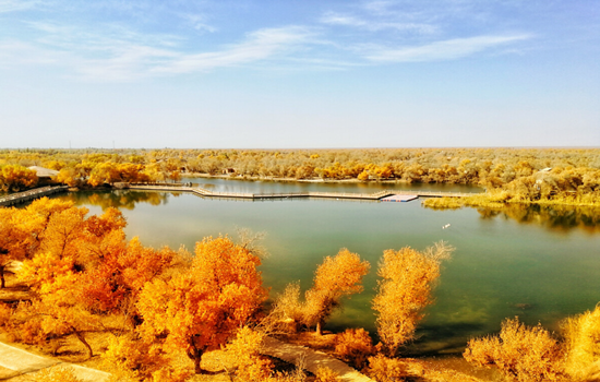
Today's scenic spot: Luntai Populus euphratica forest Park
Luntai euphratica Forest Park is located in the core part of Tarim euphratica reserve, crossing the middle reaches of Tarim River at the junction of Luntai and Weili counties. The poplar trees here are thick, the diameter of the tree is generally 60-80 cm, thick up to 1 meter, and there are common two or three poplar trees growing together, its diameter is about 1.6 meters, the height of the tree is generally 5-8 meters, the height can be more than 10 meters. The spacing of poplar trees is generally about 20 meters, and the distance of clustered trees is only 3~4 meters.
The sightseeing area is 17 km with 126 ancient poplar forest roads for visitors to enjoy the appearance of poplar; the core area also has a 13 km long circular railway connecting several large forest lakes, tourists can enjoy the desert scenery-poplar reflect the water and make the water green or golden.
Itinerary
Luntai poplar forest Park, in the backyard of the reception station, a towering tower 20 or 30 meters high looking tower, on the top of the tower, but see the blue Tarim River winding, scattered into numerous streams, streams full with poplar forest. Populus euphratica forest sea, along the Tarim River has been extended to the vast sky, very not spectacular! The forest park is colorful and changeable, with green trees, clear water and blue sky, just like a thick ink painting.
kindly reminder:
1. Fireworks are strictly prohibited in Luntai euphratica forest scenic area, and there are few shops in the scenic area. Please prepare the items for the scenic area in advance.
Day 33 Korla-Urumqi (about 550KM)
Today's attractions: Ahongkou
Ahongkou is an important part of the Bosten Lake National Wetland Park and the largest inland freshwater lake in China. There are desert, oasis, lake, reeds, lotus pond and other natural landscape, with yachts, speedboats, motor boats, water flying umbrella, water gliding, boating, fishing and other water entertainment projects. The thatched hut on the island, the appearance of primitive rustic, modern facilities, quiet and comfortable leisure environment, make people return to simplicity. Look up at the water platform, like a mirage. On the viewing platform, choose the amusement project, the slow rubber boat, the automatic lovers boat, the water slide board, driving a single motorboat, take an umbrella more visitors feel very exciting, but also can jump into the clear lake to enjoy the water once.
Itinerary
Ahongkou mouth charming scenery is bosten lake first scene, reed and different posture, some reflection ripple, some graceful, lake island birds, quiet leisurely, the air waterfowl wings fly, water fish swimming, the lotus lake, the lotus on the lake lotus blooming, delicate, is compassion.
kindly reminder:
There are more mosquitoes in Bosten Lake scenic area, please prepare mosquito repellent drops in advance.

Day 34 Urumqi-Heavenly Lake-Urumqi(about 90KM)
Today's scenic spots:heaven lake of Tian Shan
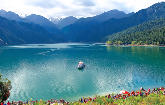
There are three water surfaces in the Heavenly Lake, in addition to the main lake, there are two water surfaces on the east and west sides, the east side is the East Little Heavenly Lake, the ancient name of Heilongtan, located 500 meters east of the Heavenly Lake, legend is the face of the Queen Mother. Under the pool for the cliff, there is a waterfall flowing down, just like a rainbow according to the sky, is spectacular, to help a scene day "hanging spring Yao hong". The west side is the West Little Heavenly Lake, also known as the Jade Woman Pool, according to legend that the Queen mother of the West wash feet, located two kilometers northwest of the Heavenly Lake. West small Heavenly Lake like a full moon, the water is clear and deep, surrounded by tower pine. If the bright moon is in the sky, the quiet shadow sinks to the wall, and the clear scene is infinite, so we also have a scene said: "Longtan blue moon". The side of the pool also flies hanging a waterfall, tens of meters high, such as the Milky Way landing, spit beads splashing jade, the scene is called "jade belt silver curtain". There is a pavilion on the pool, the pavilion view the waterfall is interesting. Eyes can see the curtain roll pool tao, pine cui water blue; ears can hear the water through the rock, sound shock rift.
Itinerary
From the hotel parking lot along the Heavenly Lake Scenic area.
After the ticket procedures, all tourists must change the interval car to enter. Every day after 10 a. m., the bus will stop at the Folk Village. All tourists have to get through the bus from the village to the next boarding point to get on the bus. Along the way, there are selling barbecue, naan, ethnic handicrafts and other stalls. After arriving at the parking lot at the top of the mountain, hiking to the lake and 1.5KM, you can walk or sit
battery car.
kindly reminder:
1. the scenic spot has strong ultraviolet light during the day, please take sunscreen measures. The lake temperature is not high, but the ultraviolet light penetration is very strong;
2. on the top of the mountain, pay more attention to keep warm (2300 meters above sea level) there are few restaurants in the scenic area, and far away from the door of the scenic spot, so if you want to stay in the scenic area for a long time, to calculate the good time to eat, otherwise you should prepare some dry food to carry.
Day 35 Urumqi-Your city
Arrange the flight / station according to the flight / train information, end the deep journey of northern Xinjiang, return to the warm home! Welcome to visit Xinjiang again!
The trip time node is for reference only, subject to the actual participants